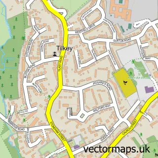
This Wakes Colne street map is a detailed vector street map covering a 750m x 750m area. Select a larger area to create and download your own vector street map of Wakes Colne.
The 750-metre map sample for Wakes Colne covers 138 mapped buildings and approximately 6.2 km of road detail, of which 6 named roads are named. The immediate area includes 1 school, 1 railway station, 1 pub and 2 MOT stations within 2 miles. The wider area around Wakes Colne features 2 tourism points of interest, 3 food and drink venues and 1 hotel. To create a larger or custom map of Wakes Colne, the map builder lets you define your own coverage area and download editable SVG, PDF and PNG files.
Create a larger editable map of Wakes Colne
Choose any area you need and generate a high-quality vector map instantly. Perfect for print, planning, design, business and personal use.

This Wakes Colne street map in Essex is available as downloadable SVG, PDF and PNG map files, or as a printed map for planning, business, display, education, local information and design work. You can also create a larger custom map area using the map selector.
What this Wakes Colne map sample shows
Wakes Colne lies within Wakes Colne Cp parish, part of Rural North ward in the Colchester District (B) local authority area. The postcode geography for this area includes the CO postcode area, the CO6 postcode district and the CO6 2 postcode sector. Residents fall under the Nhs Suffolk And North East Essex Integrated Care Board for NHS services.
Local features near Wakes Colne
Within 2 milesAmenities and services in and around Wakes Colne.
Administrative and postcode information for Wakes Colne
The local authority covering Wakes Colne is Colchester District (B), within the county of Essex. The settlement lies within Rural North ward and Wakes Colne Cp civil parish. The CO6 postcode district and CO6 2 postcode sector serve the immediate area. NHS provision in the area is delivered through East Suffolk And North Essex Nhs Foundation Trust.
Nearby street map samples around Wakes Colne


More street maps in Essex
750 metre map area coverage
Boundary, postcode and point of interest information for the 750m x 750m rectangle centred on this sample map.
Boundaries containing map centre
Constituency: Harwich and North Essex Co Const
County: Essex County
District: Colchester District (B)
Icb: NHS Essex ICB
Parish: Wakes Colne CP
Police Force: essex
Postcode District: CO6
Postcode Sector: CO6 2
Ward: Rural North Ward
Nearby boundaries intersecting sample
Parish: Chappel CP
Postcode coverage
POI category counts
Art Gallery: 2
Elementary School: 2
Gym: 2
Anglican Church: 1
Bridge: 1
British Restaurant: 1
Cafe: 1
Community Center: 1
Convenience Store: 1
History Museum: 1
Sample points of interest
- Chappel: St Barnabas
- Chappel Galleries
- Chappel Galleries
- Chappel Viaduct
- Platform 2 Catering Ltd.
- Platform Two Café
- Chappel and Wakes Colne Village Hall
- Premier Chapel Convenience
- Chappel Church of England Controlled Primary School
- Chappel Primary School
- PT Studio
- Village Hall Chappel & Wakes Colne
Create a larger editable map of Wakes Colne
This sample shows only a 750 metre area. To create a larger map of Wakes Colne, use our map builder to choose your own coverage area, add titles and download editable SVG, PDF and PNG files.
Create a custom map of Wakes Colne