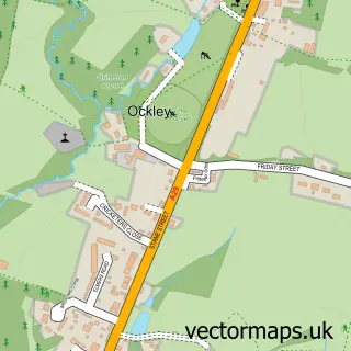
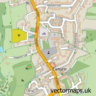
This Walliswood street map is a detailed vector street map covering a 750m x 750m area. Select a larger area to create and download your own vector street map of Walliswood.
The 750-metre map sample for Walliswood covers 143 mapped buildings and approximately 6.4 km of road detail, of which 4 named roads are named. The immediate area includes 2 pubs and 1 MOT station within 2 miles. The wider area around Walliswood features 2 food and drink venues. To create a larger or custom map of Walliswood, the map builder lets you define your own coverage area and download editable SVG, PDF and PNG files.
Create a larger editable map of Walliswood
Choose any area you need and generate a high-quality vector map instantly. Perfect for print, planning, design, business and personal use.

This Walliswood street map in Surrey is available as downloadable SVG, PDF and PNG map files, or as a printed map for planning, business, display, education, local information and design work. You can also create a larger custom map area using the map selector.
What this Walliswood map sample shows
Walliswood lies within Abinger Cp parish, part of Okewood ward in the Mole Valley District local authority area. The postcode geography for this area includes the RH postcode area, the RH5 postcode district and the RH5 5 postcode sector. Residents fall under the Nhs Surrey Heartlands Integrated Care Board for NHS services.
Local features near Walliswood
Within 2 milesAmenities and services in and around Walliswood.
Administrative and postcode information for Walliswood
The local authority covering Walliswood is Mole Valley District, within the county of Surrey. The settlement lies within Okewood ward and Abinger Cp civil parish. The RH5 postcode district and RH5 5 postcode sector serve the immediate area. NHS provision in the area is delivered through Surrey And Sussex Healthcare Nhs Trust.
Nearby street map samples around Walliswood

More street maps in Surrey
750 metre map area coverage
Boundary, postcode and point of interest information for the 750m x 750m rectangle centred on this sample map.
Boundaries containing map centre
Constituency: Dorking and Horley Co Const
County: Surrey County
District: Mole Valley District
Icb: NHS Surrey and Sussex ICB
Parish: Abinger CP
Police Force: surrey
Postcode District: RH5
Postcode Sector: RH5 5
Ward: Mickleham, Westcott & Okewood Ward
Nearby boundaries intersecting sample
No additional intersecting boundaries found.
Postcode coverage
POI category counts
Preschool: 2
Pub: 2
Car Dealer: 1
Dance Club: 1
Retail: 1
Transportation: 1
Travel Agents: 1
Sample points of interest
- Lister Jaguar
- Colourlite Company
- Oakwood Nursery School
- Okewood Nursery School
- The Scarlett Arms
- Walliswood
- V Pharma
- Silver Cars
- Highlife Conference & Incentive
Create a larger editable map of Walliswood
This sample shows only a 750 metre area. To create a larger map of Walliswood, use our map builder to choose your own coverage area, add titles and download editable SVG, PDF and PNG files.
Create a custom map of Walliswood