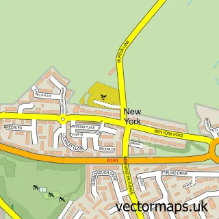
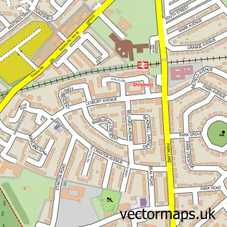
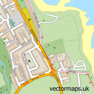
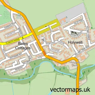
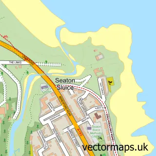
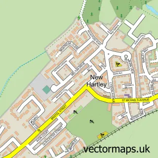
This Whitley Bay street map is a detailed vector street map covering a 750m x 750m area. Select a larger area to create and download your own vector street map of Whitley Bay.
The 750-metre map sample for Whitley Bay covers 228 mapped buildings and approximately 25.5 km of road detail, of which 45 named roads are named. The immediate area includes 1 railway station, 1 GP surgery, with 4 within 2 miles, 15 pubs and 5 MOT stations within 2 miles. The wider area around Whitley Bay features 45 food and drink venues and 27 hotels. To create a larger or custom map of Whitley Bay, the map builder lets you define your own coverage area and download editable SVG, PDF and PNG files.
Create a larger editable map of Whitley Bay
Choose any area you need and generate a high-quality vector map instantly. Perfect for print, planning, design, business and personal use.

This Whitley Bay street map in Tyne & Wear is available as downloadable SVG, PDF and PNG map files, or as a printed map for planning, business, display, education, local information and design work. You can also create a larger custom map area using the map selector.
What this Whitley Bay map sample shows
Whitley Bay lies within North Tyneside District (B) parish, part of Whitley Bay ward in the North Tyneside District (B) local authority area. The postcode geography for this area includes the NE postcode area, the NE26 postcode district and the NE26 1 postcode sector. Residents fall under the Nhs North East And North Cumbria Integrated Care Board for NHS services.
Local features near Whitley Bay
Within 2 milesAmenities and services in and around Whitley Bay.
Administrative and postcode information for Whitley Bay
The local authority covering Whitley Bay is North Tyneside District (B), within the county of Tyne & Wear. The settlement lies within Whitley Bay ward and North Tyneside District (B) civil parish. The NE26 postcode district and NE26 1 postcode sector serve the immediate area. NHS provision in the area is delivered through Northumbria Healthcare Nhs Foundation Trust.
Nearby street map samples around Whitley Bay

More street maps in Tyne & Wear
750 metre map area coverage
Boundary, postcode and point of interest information for the 750m x 750m rectangle centred on this sample map.
Boundaries containing map centre
Constituency: Tynemouth Boro Const
District: North Tyneside District (B)
Icb: NHS North East and North Cumbria ICB
Police Force: northumberland
Postcode District: NE26
Postcode Sector: NE26 2
Ward: Whitley Bay North Ward
Nearby boundaries intersecting sample
Postcode District: NE25
Postcode Sector: NE25 8, NE26 1, NE26 3
Ward: Cullercoats & Whitley Bay South Ward
Postcode coverage
POI category counts
Hotel: 27
Bed And Breakfast: 20
Cafe: 16
Beauty Salon: 15
Pub: 15
Hair Salon: 13
Professional Services: 13
Barber: 12
Flowers And Gifts Shop: 11
Indian Restaurant: 11
Sample points of interest
- Seaview Care Home, Whitley Bay
- Clerey & Co. Ltd.
- Clerey Richard & Co
- East-Coast MMA Gym
- Sands Ladies Leisure
- Life Is For Living Well - Acupuncture
- Sun Hie Acupuncture clinic
- Elemental Changes
- St Paul's Whitley Bay
- RSPCA
- British Red Cross
- Cherished
Create a larger editable map of Whitley Bay
This sample shows only a 750 metre area. To create a larger map of Whitley Bay, use our map builder to choose your own coverage area, add titles and download editable SVG, PDF and PNG files.
Create a custom map of Whitley Bay