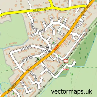
This Bosbury street map is a detailed vector street map covering a 750m x 750m area. Select a larger area to create and download your own vector street map of Bosbury.
The 750-metre map sample for Bosbury covers 87 mapped buildings and approximately 22.1 km of road detail, of which 2 named roads are named. The immediate area includes 1 school and 1 pub. The wider area around Bosbury features 1 food and drink venue. To create a larger or custom map of Bosbury, the map builder lets you define your own coverage area and download editable SVG, PDF and PNG files.
Create a larger editable map of Bosbury
Choose any area you need and generate a high-quality vector map instantly. Perfect for print, planning, design, business and personal use.

This Bosbury street map in Herefordshire is available as downloadable SVG, PDF and PNG map files, or as a printed map for planning, business, display, education, local information and design work. You can also create a larger custom map area using the map selector.
What this Bosbury map sample shows
Bosbury lies within Bosbury Cp parish, part of Hope End ward in the County Of Herefordshire local authority area. The postcode geography for this area includes the HR postcode area, the HR8 postcode district and the HR8 1 postcode sector. Residents fall under the Nhs Herefordshire And Worcestershire Integrated Care Board for NHS services.
Local features near Bosbury
Within 2 milesAmenities and services in and around Bosbury.
Administrative and postcode information for Bosbury
Bosbury lies within Bosbury Cp parish, part of Hope End ward in the County Of Herefordshire local authority area. The postcode geography for this area includes the HR postcode area, the HR8 postcode district and the HR8 1 postcode sector. Residents fall under the Nhs Herefordshire And Worcestershire Integrated Care Board for NHS services.
Nearby street map samples around Bosbury

More street maps in Herefordshire
750 metre map area coverage
Boundary, postcode and point of interest information for the 750m x 750m rectangle centred on this sample map.
Boundaries containing map centre
Constituency: North Herefordshire Co Const
District: County of Herefordshire
Icb: NHS Herefordshire and Worcestershire ICB
Parish: Bosbury CP
Police Force: west mercia
Postcode District: HR8
Postcode Sector: HR8 1
Ward: Hope End Ward
Nearby boundaries intersecting sample
No additional intersecting boundaries found.
Postcode coverage
POI category counts
Post Office: 2
Anglican Church: 1
Carpenter: 1
Commercial Industrial: 1
Marketing Consultant: 1
Naturopathic Holistic: 1
Preschool: 1
Pub: 1
Scout Hall: 1
Sample points of interest
- Bosbury: Holy Trinity
- Bosbury Benches
- Design I Q Ltd
- RJE Planning
- The Therapy Shed
- Post Office
- Post Office-Bosbury
- Jack in the Box Nursery
- The Bell Inn Bosbury
- 1st Bosbury Scout Group
Create a larger editable map of Bosbury
This sample shows only a 750 metre area. To create a larger map of Bosbury, use our map builder to choose your own coverage area, add titles and download editable SVG, PDF and PNG files.
Create a custom map of Bosbury