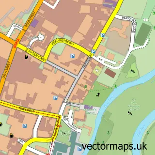
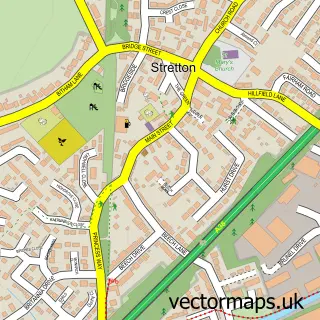
This Branston street map is a detailed vector street map covering a 750m x 750m area. Select a larger area to create and download your own vector street map of Branston.
The 750-metre map sample for Branston covers 390 mapped buildings and approximately 29.6 km of road detail, of which 28 named roads are named. The immediate area includes 1 school, 1 GP surgery, with 5 within 2 miles, 4 pubs and 1 MOT station, with 17 within 2 miles. The wider area around Branston features 1 tourism point of interest and 7 food and drink venues. To create a larger or custom map of Branston, the map builder lets you define your own coverage area and download editable SVG, PDF and PNG files.
Create a larger editable map of Branston
Choose any area you need and generate a high-quality vector map instantly. Perfect for print, planning, design, business and personal use.

This Branston street map in Staffordshire is available as downloadable SVG, PDF and PNG map files, or as a printed map for planning, business, display, education, local information and design work. You can also create a larger custom map area using the map selector.
What this Branston map sample shows
Branston lies within Branston Cp parish, part of Branston ward in the East Staffordshire District (B) local authority area. The postcode geography for this area includes the DE postcode area, the DE14 postcode district and the DE14 3 postcode sector. Residents fall under the Nhs Staffordshire And Stoke-On-Trent Integrated Care Board for NHS services.
Local features near Branston
Within 2 milesAmenities and services in and around Branston.
Administrative and postcode information for Branston
Branston lies within Branston Cp parish, part of Branston ward in the East Staffordshire District (B) local authority area. The postcode geography for this area includes the DE postcode area, the DE14 postcode district and the DE14 3 postcode sector. Residents fall under the Nhs Staffordshire And Stoke-On-Trent Integrated Care Board for NHS services.
Nearby street map samples around Branston

More street maps in Staffordshire
750 metre map area coverage
Boundary, postcode and point of interest information for the 750m x 750m rectangle centred on this sample map.
Boundaries containing map centre
Constituency: Burton and Uttoxeter Co Const
County: Staffordshire County
District: East Staffordshire District (B)
Icb: NHS Staffordshire and Stoke-on-Trent ICB
Parish: Branston CP
Police Force: staffordshire
Postcode District: DE14
Postcode Sector: DE14 3
Ward: Branston Ward
Nearby boundaries intersecting sample
Constituency: South Derbyshire Co Const
County: Derbyshire County
District: South Derbyshire District
Police Force: derbyshire
Postcode District: DE15
Postcode Sector: DE14 2, DE15 9
Ward: Linton Ward
Postcode coverage
POI category counts
Building Supply Store: 4
Professional Services: 4
Pub: 4
Beauty Salon: 3
Business Management Services: 3
Hair Salon: 3
Bakery: 2
Barbecue Restaurant: 2
British Restaurant: 2
Community Center: 2
Sample points of interest
- Clarkson Accountancy
- Deborah Gaunt
- Saint Saviour's
- Trial Systems
- Studio 56
- Burton Kia
- Birds Bakery
- the little fox bakery
- Handelsbanken Great Britain
- Miller & Carter
- Toby Carvery Burton
- Branston Barbers. Burton upon Trent
Create a larger editable map of Branston
This sample shows only a 750 metre area. To create a larger map of Branston, use our map builder to choose your own coverage area, add titles and download editable SVG, PDF and PNG files.
Create a custom map of Branston