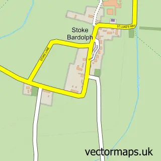
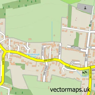
This Burton Joyce street map is a detailed vector street map covering a 750m x 750m area. Select a larger area to create and download your own vector street map of Burton Joyce.
The 750-metre map sample for Burton Joyce covers 518 mapped buildings and approximately 32.0 km of road detail, of which 33 named roads are named. The immediate area includes 1 school, 1 GP surgery, 4 pubs and 1 MOT station within 2 miles. The wider area around Burton Joyce features 4 tourism points of interest, 6 food and drink venues and 1 campsite within 2 miles. To create a larger or custom map of Burton Joyce, the map builder lets you define your own coverage area and download editable SVG, PDF and PNG files.
Create a larger editable map of Burton Joyce
Choose any area you need and generate a high-quality vector map instantly. Perfect for print, planning, design, business and personal use.

This Burton Joyce street map in Nottinghamshire is available as downloadable SVG, PDF and PNG map files, or as a printed map for planning, business, display, education, local information and design work. You can also create a larger custom map area using the map selector.
What this Burton Joyce map sample shows
Burton Joyce lies within Burton Joyce Cp parish, part of Trent Valley ward in the Gedling District (B) local authority area. The postcode geography for this area includes the NG postcode area, the NG14 postcode district and the NG14 5 postcode sector. Residents fall under the Nhs Nottingham And Nottinghamshire Integrated Care Board for NHS services.
Local features near Burton Joyce
Within 2 milesAmenities and services in and around Burton Joyce.
Administrative and postcode information for Burton Joyce
Burton Joyce lies within Burton Joyce Cp parish, part of Trent Valley ward in the Gedling District (B) local authority area. The postcode geography for this area includes the NG postcode area, the NG14 postcode district and the NG14 5 postcode sector. Residents fall under the Nhs Nottingham And Nottinghamshire Integrated Care Board for NHS services.
Nearby street map samples around Burton Joyce

More street maps in Nottinghamshire
750 metre map area coverage
Boundary, postcode and point of interest information for the 750m x 750m rectangle centred on this sample map.
Boundaries containing map centre
Constituency: Gedling Co Const
County: Nottinghamshire County
District: Gedling District (B)
Icb: NHS Nottingham and Nottinghamshire ICB
Parish: Burton Joyce CP
Police Force: nottinghamshire
Postcode District: NG14
Postcode Sector: NG14 5
Ward: Trent Valley Ward
Nearby boundaries intersecting sample
Parish: Shelford CP
Postcode District: NG12
Postcode Sector: NG12 1
Ward: Newton Ward
Postcode coverage
POI category counts
Pub: 4
Park: 3
Pet Groomer: 3
Automotive Repair: 2
Beauty And Spa: 2
Beauty Salon: 2
Building Supply Store: 2
Car Dealer: 2
Church Cathedral: 2
Community Services Non Profits: 2
Sample points of interest
- Hypnotherapy Works 4 U
- Midland Group of Chinese Bush Painters
- The Cooperative Food (BF) Burton Joyce, Burton Joyce
- Booking Secretary
- Burton Joyce Garage
- Woodview Garage
- Burtonjoyce
- Santander
- Empty Glass Limited
- Brows By Abbie
- Skin Deep, Aesthetics & Beauty
- C & T
Create a larger editable map of Burton Joyce
This sample shows only a 750 metre area. To create a larger map of Burton Joyce, use our map builder to choose your own coverage area, add titles and download editable SVG, PDF and PNG files.
Create a custom map of Burton Joyce