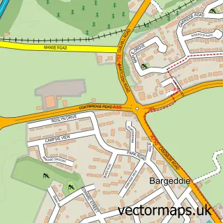
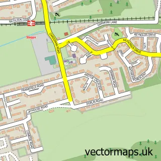
This Cambuslang street map is a detailed vector street map covering a 750m x 750m area. Select a larger area to create and download your own vector street map of Cambuslang.
The 750-metre map sample for Cambuslang covers 353 mapped buildings and approximately 19.4 km of road detail, of which 40 named roads are named. The immediate area includes 1 railway station, 1 GP surgery, with 12 within 2 miles, 7 pubs and 2 MOT stations, with 24 within 2 miles. The wider area around Cambuslang features 3 tourism points of interest, 17 food and drink venues and 1 hotel. To create a larger or custom map of Cambuslang, the map builder lets you define your own coverage area and download editable SVG, PDF and PNG files.
Create a larger editable map of Cambuslang
Choose any area you need and generate a high-quality vector map instantly. Perfect for print, planning, design, business and personal use.

This Cambuslang street map in Lanarkshire is available as downloadable SVG, PDF and PNG map files, or as a printed map for planning, business, display, education, local information and design work. You can also create a larger custom map area using the map selector.
What this Cambuslang map sample shows
Cambuslang lies within Glasgow City parish, part of Shettleston ward in the Glasgow City local authority area. The postcode geography for this area includes the G postcode area, the G32 postcode district and the G32 8 postcode sector. Residents fall under the Greater Glasgow And Clyde for NHS services.
Local features near Cambuslang
Within 2 milesAmenities and services in and around Cambuslang.
Administrative and postcode information for Cambuslang
Cambuslang lies within Glasgow City parish, part of Shettleston ward in the Glasgow City local authority area. The postcode geography for this area includes the G postcode area, the G32 postcode district and the G32 8 postcode sector. Residents fall under the Greater Glasgow And Clyde for NHS services.
Nearby street map samples around Cambuslang

More street maps in Lanarkshire
750 metre map area coverage
Boundary, postcode and point of interest information for the 750m x 750m rectangle centred on this sample map.
Boundaries containing map centre
Constituency: Rutherglen Burgh Const
District: South Lanarkshire
Icb: Lanarkshire
Postcode District: G72
Postcode Sector: G72 7
Ward: Cambuslang West Ward
Nearby boundaries intersecting sample
Postcode Sector: G72 8
Ward: Cambuslang East Ward
Postcode coverage
POI category counts
Beauty Salon: 9
Convenience Store: 8
Hair Salon: 7
Pub: 7
Beauty And Spa: 5
Coffee Shop: 5
Gym: 5
Banks: 4
Bar: 4
Chinese Restaurant: 4
Sample points of interest
- Jenkins Dunbar Accountancy
- Savinvest
- Proper Frame Displays
- Asian Tandoori Cambuslang
- Unique Bodywork
- Forster's Autocare
- KP Autos ltd
- Somervell MOT Station
- Greggs
- Speciality Cakes
- Cambuslang Banking Hub
- Cambuslang Credit Union
Create a larger editable map of Cambuslang
This sample shows only a 750 metre area. To create a larger map of Cambuslang, use our map builder to choose your own coverage area, add titles and download editable SVG, PDF and PNG files.
Create a custom map of Cambuslang