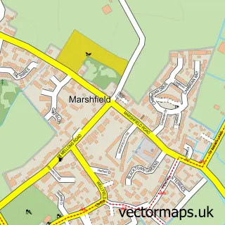
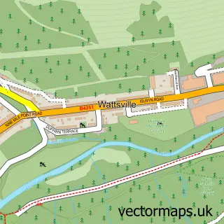
This Castleton street map is a detailed vector street map covering a 750m x 750m area. Select a larger area to create and download your own vector street map of Castleton.
The 750-metre map sample for Castleton covers 207 mapped buildings and approximately 8.7 km of road detail, of which 11 named roads are named. The immediate area includes 1 MOT station within 2 miles. The wider area around Castleton features 1 tourism point of interest and 1 hotel. To create a larger or custom map of Castleton, the map builder lets you define your own coverage area and download editable SVG, PDF and PNG files.
Create a larger editable map of Castleton
Choose any area you need and generate a high-quality vector map instantly. Perfect for print, planning, design, business and personal use.

This Castleton street map in Gwent is available as downloadable SVG, PDF and PNG map files, or as a printed map for planning, business, display, education, local information and design work. You can also create a larger custom map area using the map selector.
What this Castleton map sample shows
Castleton lies within Marshfield Community parish, part of Marshfield ward in the Casnewydd - Newport local authority area. The postcode geography for this area includes the CF postcode area, the CF3 postcode district and the CF3 2 postcode sector. Residents fall under the Aneurin Bevan University Health Board for NHS services.
Local features near Castleton
Within 2 milesAmenities and services in and around Castleton.
Administrative and postcode information for Castleton
Castleton lies within Marshfield Community parish, part of Marshfield ward in the Casnewydd - Newport local authority area. The postcode geography for this area includes the CF postcode area, the CF3 postcode district and the CF3 2 postcode sector. Residents fall under the Aneurin Bevan University Health Board for NHS services.
Nearby street map samples around Castleton

More street maps in Gwent
750 metre map area coverage
Boundary, postcode and point of interest information for the 750m x 750m rectangle centred on this sample map.
Boundaries containing map centre
Constituency: Newport West and Islwyn Co Const
District: Casnewydd - Newport
Icb: Aneurin Bevan University
Parish: Marshfield Community
Police Force: gwent
Postcode District: CF3
Postcode Sector: CF3 2
Nearby boundaries intersecting sample
Parish: Michaelstone-y-Fedw Community
Postcode Sector: CF3 6
Postcode coverage
POI category counts
Gas Station: 5
Assisted Living Facility: 1
Atms: 1
Carpet Store: 1
Castle: 1
Community Center: 1
Day Care Preschool: 1
Elementary School: 1
Event Technology Service: 1
Hotel: 1
Sample points of interest
- Barchester - Bryn Ivor Lodge Care Home
- MFG - Castleton (MRH)
- 220 Interiors
- Wentloog Castle
- Castleton and District Village Hall
- Marshfield Monkeys Daycare, Wrap Around & Holiday Club
- Marshfield Primary School
- Acevents
- ESSO MFG CASTLETON
- ESSO Station
- Esso
- Mfg Castleton
Create a larger editable map of Castleton
This sample shows only a 750 metre area. To create a larger map of Castleton, use our map builder to choose your own coverage area, add titles and download editable SVG, PDF and PNG files.
Create a custom map of Castleton