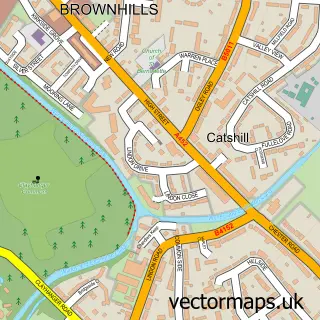
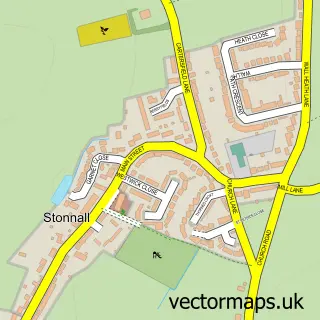
This Clayhanger street map is a detailed vector street map covering a 750m x 750m area. Select a larger area to create and download your own vector street map of Clayhanger.
The 750-metre map sample for Clayhanger covers 293 mapped buildings and approximately 15.2 km of road detail, of which 27 named roads are named. The immediate area includes 1 school, 8 GP surgeries within 2 miles and 13 MOT stations within 2 miles. The wider area around Clayhanger features 2 tourism points of interest and 1 food and drink venue. To create a larger or custom map of Clayhanger, the map builder lets you define your own coverage area and download editable SVG, PDF and PNG files.
Create a larger editable map of Clayhanger
Choose any area you need and generate a high-quality vector map instantly. Perfect for print, planning, design, business and personal use.

This Clayhanger street map in West Midlands is available as downloadable SVG, PDF and PNG map files, or as a printed map for planning, business, display, education, local information and design work. You can also create a larger custom map area using the map selector.
What this Clayhanger map sample shows
Clayhanger lies within Walsall District (B) parish, part of Brownhills ward in the Walsall District (B) local authority area. The postcode geography for this area includes the WS postcode area, the WS8 postcode district and the WS8 7 postcode sector. Residents fall under the Nhs Black Country Integrated Care Board for NHS services.
Local features near Clayhanger
Within 2 milesAmenities and services in and around Clayhanger.
Administrative and postcode information for Clayhanger
The local authority covering Clayhanger is Walsall District (B), within the county of West Midlands. The settlement lies within Brownhills ward and Walsall District (B) civil parish. The WS8 postcode district and WS8 7 postcode sector serve the immediate area. NHS provision in the area is delivered through Walsall Healthcare Nhs Trust.
Nearby street map samples around Clayhanger


More street maps in West Midlands
750 metre map area coverage
Boundary, postcode and point of interest information for the 750m x 750m rectangle centred on this sample map.
Boundaries containing map centre
Constituency: Aldridge-Brownhills Boro Const
District: Walsall District (B)
Icb: NHS Black Country ICB
Police Force: west midlands
Postcode District: WS8
Postcode Sector: WS8 7
Ward: Brownhills Ward
Nearby boundaries intersecting sample
Postcode Sector: WS8 6
Postcode coverage
POI category counts
Building Supply Store: 3
Electrician: 3
Banks: 2
Beauty Salon: 2
Butcher Shop: 2
Contractor: 2
Convenience Store: 2
Elementary School: 2
Flowers And Gifts Shop: 2
Anglican Church: 1
Sample points of interest
- Clayhanger Holy Trinity Worship Centre
- Midcounties Co-Op Clayhanger, Clayhanger
- PD Steering Wheels
- Lloyds Bank
- NatWest
- House of Treatments
- The Vanity Case Beauty Studio
- Darren Russell Plumbing & Heating
- Hidden Space Stair Storage
- K & V Berry Window Cleaning
- Edmund Howdle Butchers
- Howdle Edmund
Create a larger editable map of Clayhanger
This sample shows only a 750 metre area. To create a larger map of Clayhanger, use our map builder to choose your own coverage area, add titles and download editable SVG, PDF and PNG files.
Create a custom map of Clayhanger