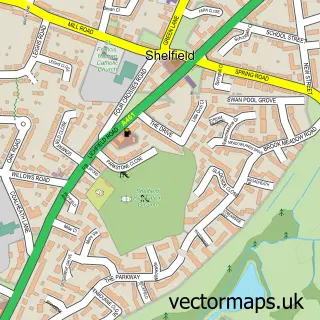
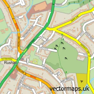
This Stonnall street map is a detailed vector street map covering a 750m x 750m area. Select a larger area to create and download your own vector street map of Stonnall.
The 750-metre map sample for Stonnall covers 227 mapped buildings and approximately 16.9 km of road detail, of which 13 named roads are named. The immediate area includes 1 school, 3 GP surgeries within 2 miles, 3 pubs and 13 MOT stations within 2 miles. The wider area around Stonnall features 1 tourism point of interest and 3 food and drink venues. To create a larger or custom map of Stonnall, the map builder lets you define your own coverage area and download editable SVG, PDF and PNG files.
Create a larger editable map of Stonnall
Choose any area you need and generate a high-quality vector map instantly. Perfect for print, planning, design, business and personal use.

This Stonnall street map in Staffordshire is available as downloadable SVG, PDF and PNG map files, or as a printed map for planning, business, display, education, local information and design work. You can also create a larger custom map area using the map selector.
What this Stonnall map sample shows
Stonnall lies within Shenstone Cp parish, part of Little Aston & Stonnall ward in the Lichfield District local authority area. The postcode geography for this area includes the WS postcode area, the WS14 postcode district and the WS14 0 postcode sector. Residents fall under the Nhs Staffordshire And Stoke-On-Trent Integrated Care Board for NHS services.
Local features near Stonnall
Within 2 milesAmenities and services in and around Stonnall.
Administrative and postcode information for Stonnall
Stonnall lies within Shenstone Cp parish, part of Little Aston & Stonnall ward in the Lichfield District local authority area. The postcode geography for this area includes the WS postcode area, the WS14 postcode district and the WS14 0 postcode sector. Residents fall under the Nhs Staffordshire And Stoke-On-Trent Integrated Care Board for NHS services.
Nearby street map samples around Stonnall

More street maps in Staffordshire

750 metre map area coverage
Boundary, postcode and point of interest information for the 750m x 750m rectangle centred on this sample map.
Boundaries containing map centre
Constituency: Tamworth Co Const
County: Staffordshire County
District: Lichfield District
Icb: NHS Black Country ICB
Parish: Shenstone CP
Police Force: staffordshire
Postcode District: WS9
Postcode Sector: WS9 9
Ward: Little Aston & Stonnall Ward
Nearby boundaries intersecting sample
No additional intersecting boundaries found.
Postcode coverage
POI category counts
Pub: 3
Community Center: 2
Convenience Store: 2
Accountant: 1
Active Life: 1
Atms: 1
Automotive Repair: 1
Barber: 1
Beauty Salon: 1
Childrens Clothing Store: 1
Sample points of interest
- Assured Accounting
- Boogie Bounce WS9
- Main Street News & Off Licence, Stonnall
- Lanes Cars
- Wicked Hair & Beauty UK
- Just Hair Stonnall
- The Bespoke Tailor
- Essential Build Clean
- Stonnall Village Hall
- Stonnall Youth & Community Centre
- Premier
- SPAR Stonnal
Create a larger editable map of Stonnall
This sample shows only a 750 metre area. To create a larger map of Stonnall, use our map builder to choose your own coverage area, add titles and download editable SVG, PDF and PNG files.
Create a custom map of Stonnall