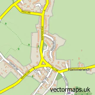
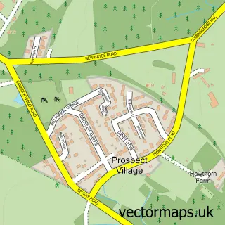
This Burntwood street map is a detailed vector street map covering a 750m x 750m area. Select a larger area to create and download your own vector street map of Burntwood.
The 750-metre map sample for Burntwood covers 502 mapped buildings and approximately 25.2 km of road detail, of which 45 named roads are named. The immediate area includes 2 schools, 2 GP surgeries within 2 miles, 1 pub and 1 MOT station, with 8 within 2 miles. The wider area around Burntwood features 2 tourism points of interest and 1 food and drink venue. To create a larger or custom map of Burntwood, the map builder lets you define your own coverage area and download editable SVG, PDF and PNG files.
Create a larger editable map of Burntwood
Choose any area you need and generate a high-quality vector map instantly. Perfect for print, planning, design, business and personal use.

This Burntwood street map in Staffordshire is available as downloadable SVG, PDF and PNG map files, or as a printed map for planning, business, display, education, local information and design work. You can also create a larger custom map area using the map selector.
What this Burntwood map sample shows
Burntwood lies within Burntwood Cp parish, part of Summerfield & All Saints ward in the Lichfield District local authority area. The postcode geography for this area includes the WS postcode area, the WS7 postcode district and the WS7 0 postcode sector. Residents fall under the Nhs Staffordshire And Stoke-On-Trent Integrated Care Board for NHS services.
Local features near Burntwood
Within 2 milesAmenities and services in and around Burntwood.
Administrative and postcode information for Burntwood
Burntwood lies within Burntwood Cp parish, part of Summerfield & All Saints ward in the Lichfield District local authority area. The postcode geography for this area includes the WS postcode area, the WS7 postcode district and the WS7 0 postcode sector. Residents fall under the Nhs Staffordshire And Stoke-On-Trent Integrated Care Board for NHS services.
Nearby street map samples around Burntwood


More street maps in Staffordshire
750 metre map area coverage
Boundary, postcode and point of interest information for the 750m x 750m rectangle centred on this sample map.
Boundaries containing map centre
Constituency: Lichfield Co Const
County: Staffordshire County
District: Lichfield District
Icb: NHS Black Country ICB
Parish: Burntwood CP
Police Force: staffordshire
Postcode District: WS7
Postcode Sector: WS7 9
Ward: Summerfield & All Saints Ward
Nearby boundaries intersecting sample
Postcode Sector: WS7 0, WS7 2, WS7 4
Ward: Boney Hay & Central Ward, Highfield Ward
Postcode coverage
POI category counts
Automotive Repair: 7
Building Supply Store: 5
Convenience Store: 4
Key And Locksmith: 4
Beauty Salon: 3
Elementary School: 3
Gas Station: 3
Industrial Equipment: 3
Professional Services: 3
Rental Kiosks: 3
Sample points of interest
- Llipy
- J & M Electrical Supplies
- BR Spar Burntwood
- The Cooperative Food (BF) Morley Road, Chase Terrace
- Burntwood Valeting Centre
- GR8 Reflection detailing
- E30 Centre BMW
- Lovett Upholstery
- PDS Upholstery
- Second City Leasing
- Draper Vehicle Solutions
- Chase M G
Create a larger editable map of Burntwood
This sample shows only a 750 metre area. To create a larger map of Burntwood, use our map builder to choose your own coverage area, add titles and download editable SVG, PDF and PNG files.
Create a custom map of Burntwood