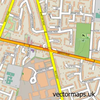
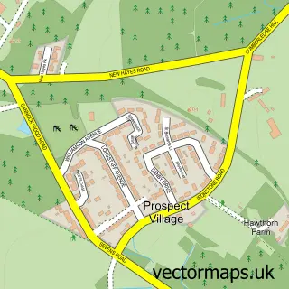
This Woodhouses street map is a detailed vector street map covering a 750m x 750m area. Select a larger area to create and download your own vector street map of Woodhouses.
The 750-metre map sample for Woodhouses covers 291 mapped buildings and approximately 15.3 km of road detail, of which 21 named roads are named. The immediate area includes 2 GP surgeries within 2 miles and 2 MOT stations within 2 miles. The wider area around Woodhouses features 1 tourism point of interest and 1 food and drink venue. To create a larger or custom map of Woodhouses, the map builder lets you define your own coverage area and download editable SVG, PDF and PNG files.
Create a larger editable map of Woodhouses
Choose any area you need and generate a high-quality vector map instantly. Perfect for print, planning, design, business and personal use.

This Woodhouses street map in Staffordshire is available as downloadable SVG, PDF and PNG map files, or as a printed map for planning, business, display, education, local information and design work. You can also create a larger custom map area using the map selector.
What this Woodhouses map sample shows
Woodhouses lies within Burntwood Cp parish, part of Highfield ward in the Lichfield District local authority area. The postcode geography for this area includes the WS postcode area, the WS7 postcode district and the WS7 0 postcode sector. Residents fall under the Nhs Staffordshire And Stoke-On-Trent Integrated Care Board for NHS services.
Local features near Woodhouses
Within 2 milesAmenities and services in and around Woodhouses.
Administrative and postcode information for Woodhouses
Woodhouses lies within Burntwood Cp parish, part of Highfield ward in the Lichfield District local authority area. The postcode geography for this area includes the WS postcode area, the WS7 postcode district and the WS7 0 postcode sector. Residents fall under the Nhs Staffordshire And Stoke-On-Trent Integrated Care Board for NHS services.
Nearby street map samples around Woodhouses


More street maps in Staffordshire
750 metre map area coverage
Boundary, postcode and point of interest information for the 750m x 750m rectangle centred on this sample map.
Boundaries containing map centre
Constituency: Lichfield Co Const
County: Staffordshire County
District: Lichfield District
Icb: NHS Black Country ICB
Parish: Burntwood CP
Police Force: staffordshire
Postcode District: WS7
Postcode Sector: WS7 9
Ward: Highfield Ward
Nearby boundaries intersecting sample
No additional intersecting boundaries found.
Postcode coverage
POI category counts
Sports Club And League: 2
Accountant: 1
Attractions And Activities: 1
Auto Detailing: 1
Bar: 1
Building Supply Store: 1
Business Consulting: 1
Cafe: 1
Cleaning Services: 1
Employment Agencies: 1
Sample points of interest
- Sharp Bookkeeping Ltd
- St Matthews Estate
- Approved Valeting UK Ltd
- The Nut House
- Bayley Property Services
- Rosevale Holdings Limited
- Strawberry Fields
- Approved Valeting UK
- Habib Rehman
- Hire Magic Mirror
- Coulter Lane Farm
- Hodson-Walker, S & P
Create a larger editable map of Woodhouses
This sample shows only a 750 metre area. To create a larger map of Woodhouses, use our map builder to choose your own coverage area, add titles and download editable SVG, PDF and PNG files.
Create a custom map of Woodhouses