Vector Maps logo
Home Why it works Popular maps Districts Samples Customizer Create Your Map
VectorMaps.uk
Home Popular maps Districts Samples Customizer Create Your Map Privacy Disclaimer
Home / UK Maps / South Yorkshire / Darton Map

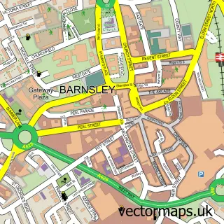
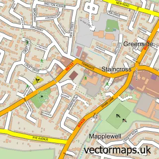
This Darton street map is a detailed vector street map covering a 750m x 750m area. Select a larger area to create and download your own vector street map of Darton.

Darton is a village in South Yorkshire, in the Yorkshire And The Humber of England. Historically, the area formed part of Yorkshire. The settlement falls within the Barnsley Central parliamentary constituency. It is served by the S75 postcode district, wi

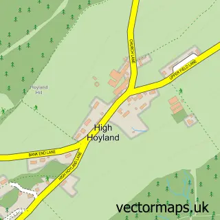
The 750-metre map sample for Darton covers 309 mapped buildings and approximately 10.5 km of road detail, of which 15 named roads are named. The immediate area includes 3 GP surgeries within 2 miles, 1 pub and 1 MOT station, with 11 within 2 miles. The wider area around Darton features 1 tourism point of interest, 1 food and drink venue and 1 hotel. To create a larger or custom map of Darton, the map builder lets you define your own coverage area and download editable SVG, PDF and PNG files.

309Buildings
10.45 kmRoads
15Named roads
13,328Residents within 2 miles
Create your own

Create a larger editable map of Darton

Choose any area you need and generate a high-quality vector map instantly. Perfect for print, planning, design, business and personal use.

Choose any location
Editable SVG files
Any size up to A0
PDF, PNG & more
Instant download
High quality guaranteed
Create My Custom Map
Secure, private & no credit card required
Darton Vector Street Map
750m Sample
Darton vector street map sample showing roads, buildings and local features in a 750 metre preview area
Buy Darton Map Print from £12.95 Buy Darton Digital Map from £6

This Darton street map in South Yorkshire is available as downloadable SVG, PDF and PNG map files, or as a printed map for planning, business, display, education, local information and design work. You can also create a larger custom map area using the map selector.

What this Darton map sample shows

Darton lies within Barnsley District (B) parish, part of Darton West ward in the Barnsley District (B) local authority area. The postcode geography for this area includes the S postcode area, the S75 postcode district and the S75 5 postcode sector. Residents fall under the Nhs South Yorkshire Integrated Care Board for NHS services.

Local features near Darton

Within 2 miles

Amenities and services in and around Darton.

3 GP surgeries within 2 miles
1 MOT stations 11 within 2 miles
1 Tourism & leisure
1 Food & drink
1 Pubs
1 Hotels
1 Vehicle services

Counts are approximate and based on publicly available data.

Administrative and postcode information for Darton

Darton lies within Barnsley District (B) parish, part of Darton West ward in the Barnsley District (B) local authority area. The postcode geography for this area includes the S postcode area, the S75 postcode district and the S75 5 postcode sector. Residents fall under the Nhs South Yorkshire Integrated Care Board for NHS services.

Parish BARNSLEY DISTRICT (B)
Ward Darton West
District / local authority Barnsley District (B)
County South Yorkshire
Historic county Yorkshire
Postcode district S75
Postcode sector S75 5
Parliamentary constituency Barnsley Central
Region Yorkshire and the Humber
Country England

Nearby street map samples around Darton

Street map sample of Barnsley, South Yorkshire Barnsley Town - South Yorkshire - 2.7 miles Street map sample of Wakefield, West Yorkshire Wakefield City - West Yorkshire - 7.2 miles Street map sample of Kexbrough, South Yorkshire Kexbrough Village - South Yorkshire - 0.8 miles Street map sample of Barugh Green, South Yorkshire Barugh Green Village - South Yorkshire - 0.9 miles Street map sample of Staincross, South Yorkshire Staincross Village - South Yorkshire - 1.0 miles Street map sample of Mapplewell, South Yorkshire Mapplewell Village - South Yorkshire - 1.0 miles Street map sample of Higham, South Yorkshire Higham Village - South Yorkshire - 1.4 miles Street map sample of Cawthorne, South Yorkshire Cawthorne Village - South Yorkshire - 1.9 miles Street map sample of Woolley, West Yorkshire Woolley Village - West Yorkshire - 2.3 miles Street map sample of High Hoyland, South Yorkshire High Hoyland Village - South Yorkshire - 2.5 miles

More street maps in South Yorkshire

Street map sample of Kexbrough, South Yorkshire Kexbrough Village - 0.8 miles Street map sample of Barugh Green, South Yorkshire Barugh Green Village - 0.9 miles Street map sample of Staincross, South Yorkshire Staincross Village - 1.0 miles Street map sample of Mapplewell, South Yorkshire Mapplewell Village - 1.0 miles Street map sample of Higham, South Yorkshire Higham Village - 1.4 miles

750 metre map area coverage

Boundary, postcode and point of interest information for the 750m x 750m rectangle centred on this sample map.

Boundaries containing map centre

Constituency: Barnsley North Co Const

District: Barnsley District (B)

Icb: NHS South Yorkshire ICB

Police Force: south yorkshire

Postcode District: S75

Postcode Sector: S75 5

Ward: Darton West Ward

Nearby boundaries intersecting sample

Postcode Sector: S75 1

Ward: Darton East Ward

Postcode coverage

S75 S75 5 S75 1

POI category counts

Food Beverage Service Distribution: 3

Carpet Store: 2

Convenience Store: 2

Professional Services: 2

Retail: 2

Appliance Manufacturer: 1

Automotive Repair: 1

Bathroom Remodeling: 1

Building Supply Store: 1

Business: 1

Sample points of interest

  • Xeracarb Appliance Manufacturer
  • Robert Thompson Central Garage Automotive Repair
  • Plumb It Bathroom Remodeling
  • Apex Lofts Building Supply Store
  • BAPP Group Contracts Ltd Business
  • Shaw Carpet Factory Carpet Store
  • Shaw Carpets Barnsley Carpet Store
  • Barnsley Council North Area Team Community Services Non Profits
  • Bargain Booze Select Convenience Convenience Store
  • Colin Sykes Ltd Convenience Store
  • Poundland Discount Store
  • Frozen Value Food Beverage Service Distribution

Create a larger editable map of Darton

This sample shows only a 750 metre area. To create a larger map of Darton, use our map builder to choose your own coverage area, add titles and download editable SVG, PDF and PNG files.

Create a custom map of Darton

Phone 01751 473136 | Copyright Vectormaps.uk 2026

Samples Customizer Privacy Disclaimer
Darton Vector Street Map
Darton enlarged street map sample showing a 750 metre preview area