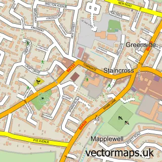
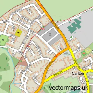
This Staincross street map is a detailed vector street map covering a 750m x 750m area. Select a larger area to create and download your own vector street map of Staincross.
The 750-metre map sample for Staincross covers 631 mapped buildings and approximately 16.9 km of road detail, of which 40 named roads are named. The immediate area includes 3 GP surgeries within 2 miles and 10 MOT stations within 2 miles. To create a larger or custom map of Staincross, the map builder lets you define your own coverage area and download editable SVG, PDF and PNG files.
Create a larger editable map of Staincross
Choose any area you need and generate a high-quality vector map instantly. Perfect for print, planning, design, business and personal use.

This Staincross street map in South Yorkshire is available as downloadable SVG, PDF and PNG map files, or as a printed map for planning, business, display, education, local information and design work. You can also create a larger custom map area using the map selector.
What this Staincross map sample shows
Staincross lies within Barnsley District (B) parish, part of Darton East ward in the Barnsley District (B) local authority area. The postcode geography for this area includes the S postcode area, the S75 postcode district and the S75 5 postcode sector. Residents fall under the Nhs South Yorkshire Integrated Care Board for NHS services.
Local features near Staincross
Within 2 milesAmenities and services in and around Staincross.
Administrative and postcode information for Staincross
The local authority covering Staincross is Barnsley District (B), within the county of South Yorkshire. The settlement lies within Darton East ward and Barnsley District (B) civil parish. The S75 postcode district and S75 5 postcode sector serve the immediate area. NHS provision in the area is delivered through Barnsley Hospital Nhs Foundation Trust.
Nearby street map samples around Staincross

More street maps in South Yorkshire
750 metre map area coverage
Boundary, postcode and point of interest information for the 750m x 750m rectangle centred on this sample map.
Boundaries containing map centre
Constituency: Barnsley North Co Const
District: Barnsley District (B)
Icb: NHS South Yorkshire ICB
Police Force: south yorkshire
Postcode District: S75
Postcode Sector: S75 6
Ward: Darton East Ward
Nearby boundaries intersecting sample
Postcode Sector: S75 5
Postcode coverage
POI category counts
Information Technology Company: 2
Post Office: 2
Automotive Repair: 1
Beauty Salon: 1
Bicycle Shop: 1
Business Management Services: 1
Ceiling Service: 1
Community Services Non Profits: 1
Convenience Store: 1
Corporate Office: 1
Sample points of interest
- Evolution Body and Paint
- The Little Beauty Room
- Zed Bike Wheels
- Post Office-Windhill
- DPR Roofing
- Mapplewell Village
- Go Local Extra
- Lojix Limited
- Essentially Aloe
- driveJohnson's Barnsley
- L C Inspection Services
- Staincross Apiaries
Create a larger editable map of Staincross
This sample shows only a 750 metre area. To create a larger map of Staincross, use our map builder to choose your own coverage area, add titles and download editable SVG, PDF and PNG files.
Create a custom map of Staincross