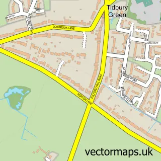
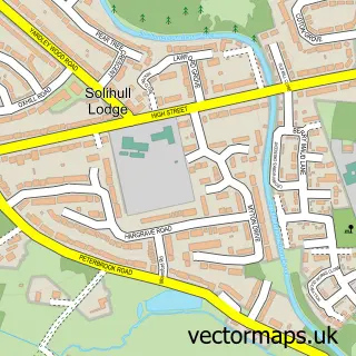
This Dickens Heath street map is a detailed vector street map covering a 750m x 750m area. Select a larger area to create and download your own vector street map of Dickens Heath.
The 750-metre map sample for Dickens Heath covers 591 mapped buildings and approximately 40.3 km of road detail, of which 44 named roads are named. The immediate area includes 1 school, 5 GP surgeries within 2 miles, 1 pub and 14 MOT stations within 2 miles. The wider area around Dickens Heath features 2 tourism points of interest and 8 food and drink venues. To create a larger or custom map of Dickens Heath, the map builder lets you define your own coverage area and download editable SVG, PDF and PNG files.
Create a larger editable map of Dickens Heath
Choose any area you need and generate a high-quality vector map instantly. Perfect for print, planning, design, business and personal use.

This Dickens Heath street map in West Midlands is available as downloadable SVG, PDF and PNG map files, or as a printed map for planning, business, display, education, local information and design work. You can also create a larger custom map area using the map selector.
What this Dickens Heath map sample shows
Dickens Heath lies within Dickens Heath Cp parish, part of Blythe ward in the Solihull District (B) local authority area. The postcode geography for this area includes the B postcode area, the B90 postcode district and the B90 1 postcode sector. Residents fall under the Nhs Birmingham And Solihull Integrated Care Board for NHS services.
Local features near Dickens Heath
Within 2 milesAmenities and services in and around Dickens Heath.
Administrative and postcode information for Dickens Heath
The local authority covering Dickens Heath is Solihull District (B), within the county of West Midlands. The settlement lies within Blythe ward and Dickens Heath Cp civil parish. The B90 postcode district and B90 1 postcode sector serve the immediate area. NHS provision in the area is delivered through University Hospitals Birmingham Nhs Foundation Trust.
Nearby street map samples around Dickens Heath


More street maps in West Midlands
750 metre map area coverage
Boundary, postcode and point of interest information for the 750m x 750m rectangle centred on this sample map.
Boundaries containing map centre
Constituency: Solihull West and Shirley Boro Const
District: Solihull District (B)
Icb: NHS Birmingham and Solihull ICB
Parish: Dickens Heath CP
Police Force: west midlands
Postcode District: B90
Postcode Sector: B90 1
Ward: Blythe Ward
Nearby boundaries intersecting sample
No additional intersecting boundaries found.
Postcode coverage
POI category counts
Beauty Salon: 5
Coffee Shop: 3
Convenience Store: 3
Furniture Store: 3
Hair Salon: 3
Restaurant: 3
Skin Care: 3
Advertising Agency: 2
Automobile Leasing: 2
Department Store: 2
Sample points of interest
- K80 Sports Therapy
- Mark Hobin Design
- Wordsmith Communication Uk Limited
- Holistic Oasis Clinic
- Salsa King - Birmingham & Solihull
- The Seasons Art Class Solihull
- Jjrs Details Ltd - No.1 in Mobile valeting and detailing in Solihull & shirley
- Car and Van Lease Supermarket
- CarLease247.com
- JJRS Details Ltd
- Baretto Bakes
- Mortons Kitchen Bar & Deli
Create a larger editable map of Dickens Heath
This sample shows only a 750 metre area. To create a larger map of Dickens Heath, use our map builder to choose your own coverage area, add titles and download editable SVG, PDF and PNG files.
Create a custom map of Dickens Heath