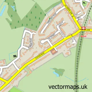
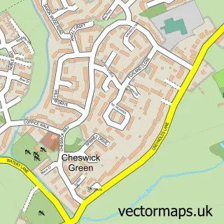
This Tidbury Green street map is a detailed vector street map covering a 750m x 750m area. Select a larger area to create and download your own vector street map of Tidbury Green.
The 750-metre map sample for Tidbury Green covers 302 mapped buildings and approximately 24.1 km of road detail, of which 15 named roads are named. The immediate area includes 1 school, 3 GP surgeries within 2 miles and 5 MOT stations within 2 miles. The wider area around Tidbury Green features 1 food and drink venue. To create a larger or custom map of Tidbury Green, the map builder lets you define your own coverage area and download editable SVG, PDF and PNG files.
Create a larger editable map of Tidbury Green
Choose any area you need and generate a high-quality vector map instantly. Perfect for print, planning, design, business and personal use.

This Tidbury Green street map in West Midlands is available as downloadable SVG, PDF and PNG map files, or as a printed map for planning, business, display, education, local information and design work. You can also create a larger custom map area using the map selector.
What this Tidbury Green map sample shows
Tidbury Green lies within Dickens Heath Cp parish, part of Blythe ward in the Solihull District (B) local authority area. The postcode geography for this area includes the B postcode area, the B90 postcode district and the B90 1 postcode sector. Residents fall under the Nhs Birmingham And Solihull Integrated Care Board for NHS services.
Local features near Tidbury Green
Within 2 milesAmenities and services in and around Tidbury Green.
Administrative and postcode information for Tidbury Green
Tidbury Green lies within Dickens Heath Cp parish, part of Blythe ward in the Solihull District (B) local authority area. The postcode geography for this area includes the B postcode area, the B90 postcode district and the B90 1 postcode sector. Residents fall under the Nhs Birmingham And Solihull Integrated Care Board for NHS services.
Nearby street map samples around Tidbury Green


More street maps in West Midlands
750 metre map area coverage
Boundary, postcode and point of interest information for the 750m x 750m rectangle centred on this sample map.
Boundaries containing map centre
Constituency: Solihull West and Shirley Boro Const
District: Solihull District (B)
Icb: NHS Birmingham and Solihull ICB
Parish: Tidbury Green CP
Police Force: west midlands
Postcode District: B90
Postcode Sector: B90 1
Ward: Blythe Ward
Nearby boundaries intersecting sample
Postcode District: B94
Postcode Sector: B94 5
Postcode coverage
POI category counts
Automotive Repair: 1
Beauty Product Supplier: 1
Car Dealer: 1
Farmers Market: 1
Gardener: 1
Home Goods Store: 1
Key And Locksmith: 1
Landscape Architect: 1
Restaurant: 1
Used Car Dealer: 1
Sample points of interest
- Tidbury Green Garage
- Bliss Beauty And Nail Salon
- Steve Lane Cars
- Wythall & Hollywood Country Market
- Eagle Home Improvements
- Leader Automotive
- Armasafe
- Chandlerstone Ltd.
- Any Occasion Cakes
- Steve Lanes
Create a larger editable map of Tidbury Green
This sample shows only a 750 metre area. To create a larger map of Tidbury Green, use our map builder to choose your own coverage area, add titles and download editable SVG, PDF and PNG files.
Create a custom map of Tidbury Green