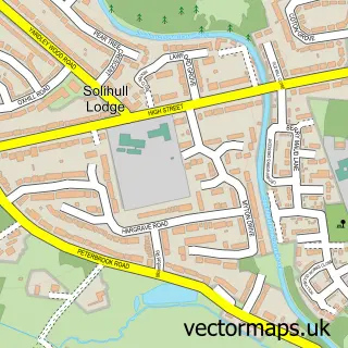
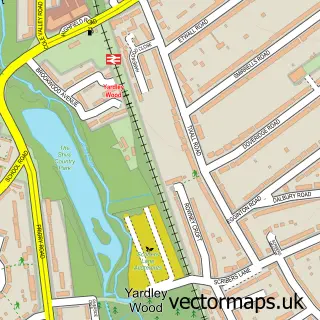
This Highters Heath street map is a detailed vector street map covering a 750m x 750m area. Select a larger area to create and download your own vector street map of Highters Heath.
The 750-metre map sample for Highters Heath covers 410 mapped buildings and approximately 36.3 km of road detail, of which 32 named roads are named. The immediate area includes 1 school, 10 GP surgeries within 2 miles and 10 MOT stations within 2 miles. The wider area around Highters Heath features 1 tourism point of interest, 2 food and drink venues and 1 hotel. To create a larger or custom map of Highters Heath, the map builder lets you define your own coverage area and download editable SVG, PDF and PNG files.
Create a larger editable map of Highters Heath
Choose any area you need and generate a high-quality vector map instantly. Perfect for print, planning, design, business and personal use.

This Highters Heath street map in West Midlands is available as downloadable SVG, PDF and PNG map files, or as a printed map for planning, business, display, education, local information and design work. You can also create a larger custom map area using the map selector.
What this Highters Heath map sample shows
Highters Heath lies within Wythall Cp parish, part of Drakes Cross ward in the Bromsgrove District local authority area. The postcode geography for this area includes the B postcode area, the B47 postcode district and the B47 5 postcode sector. Residents fall under the Nhs Herefordshire And Worcestershire Integrated Care Board for NHS services.
Local features near Highters Heath
Within 2 milesAmenities and services in and around Highters Heath.
Administrative and postcode information for Highters Heath
Highters Heath lies within Wythall Cp parish, part of Drakes Cross ward in the Bromsgrove District local authority area. The postcode geography for this area includes the B postcode area, the B47 postcode district and the B47 5 postcode sector. Residents fall under the Nhs Herefordshire And Worcestershire Integrated Care Board for NHS services.
Nearby street map samples around Highters Heath


More street maps in West Midlands
750 metre map area coverage
Boundary, postcode and point of interest information for the 750m x 750m rectangle centred on this sample map.
Boundaries containing map centre
Constituency: Birmingham Selly Oak Boro Const
District: Birmingham District (B)
Icb: NHS Birmingham and Solihull ICB
Police Force: west midlands
Postcode District: B14
Postcode Sector: B14 5
Ward: Highter's Heath Ward
Nearby boundaries intersecting sample
Constituency: Bromsgrove Co Const
County: Worcestershire County
District: Bromsgrove District
Icb: NHS Herefordshire and Worcestershire ICB
Parish: Wythall CP
Police Force: west mercia
Postcode District: B47
Postcode Sector: B14 4, B47 5
Ward: Hollywood Ward, Wythall East Ward
Postcode coverage
POI category counts
Beauty Salon: 3
Building Supply Store: 3
Beauty And Spa: 2
Hair Salon: 2
Jewelry Store: 2
Land Surveying: 2
Package Locker: 2
Real Estate Agent: 2
Web Designer: 2
Active Life: 1
Sample points of interest
- Carrefour
- Pets in Pastel
- Highters Heath Convenience Store
- Halfords
- ChipsAway South Birmingham
- Lukes barbers
- Kim Hanson Hair
- Mimi Luxe Salon - Hair by Shadine
- Beyoutifulbyclaire
- Born Beautiful
- Nails & Beauty by TRACY MAY
- Infinity Brewing
Create a larger editable map of Highters Heath
This sample shows only a 750 metre area. To create a larger map of Highters Heath, use our map builder to choose your own coverage area, add titles and download editable SVG, PDF and PNG files.
Create a custom map of Highters Heath