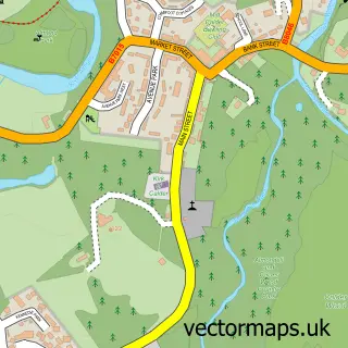
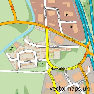
This East Calder street map is a detailed vector street map covering a 750m x 750m area. Select a larger area to create and download your own vector street map of East Calder.
The 750-metre map sample for East Calder covers 240 mapped buildings and approximately 12.9 km of road detail, of which 16 named roads are named. The immediate area includes 1 GP surgery, with 2 within 2 miles, 1 pub and 9 MOT stations within 2 miles. The wider area around East Calder features 1 tourism point of interest, 7 food and drink venues and 2 campsites within 2 miles. To create a larger or custom map of East Calder, the map builder lets you define your own coverage area and download editable SVG, PDF and PNG files.
Create a larger editable map of East Calder
Choose any area you need and generate a high-quality vector map instantly. Perfect for print, planning, design, business and personal use.

This East Calder street map in West Lothian is available as downloadable SVG, PDF and PNG map files, or as a printed map for planning, business, display, education, local information and design work. You can also create a larger custom map area using the map selector.
What this East Calder map sample shows
East Calder lies within West Lothian parish, part of East Livingston And East Calder ward in the West Lothian local authority area. The postcode geography for this area includes the EH postcode area, the EH53 postcode district and the EH53 0 postcode sector. Residents fall under the Lothian for NHS services.
Local features near East Calder
Within 2 milesAmenities and services in and around East Calder.
Administrative and postcode information for East Calder
The local authority covering East Calder is West Lothian, within the county of West Lothian. The settlement lies within East Livingston And East Calder ward and West Lothian civil parish. The EH53 postcode district and EH53 0 postcode sector serve the immediate area. NHS provision in the area is delivered through Lothian.
Nearby street map samples around East Calder

More street maps in West Lothian
750 metre map area coverage
Boundary, postcode and point of interest information for the 750m x 750m rectangle centred on this sample map.
Boundaries containing map centre
Constituency: Livingston Co Const
District: West Lothian
Icb: Lothian
Postcode District: EH53
Postcode Sector: EH53 0
Ward: East Livingston and East Calder Ward
Nearby boundaries intersecting sample
No additional intersecting boundaries found.
Postcode coverage
POI category counts
Cafe: 4
Beauty Salon: 3
Pharmacy: 3
Beauty And Spa: 2
Church Cathedral: 2
Convenience Store: 2
Dentist: 2
Elementary School: 2
Industrial Equipment: 2
Pet Groomer: 2
Sample points of interest
- The Green Tree Tavern Broxburn
- Colin Povey Gallery
- Dunbyus
- AutoTech Smart Mobile Body Repairs
- TJ's Barbers
- Murphy's Hair & Fades
- Narnia Hair Design
- Jennifer & Gillian's Beauty Therapy
- Naileditbyrachh
- Utopia Hair & Beauty
- William Hill
- MHPS Property Services
Create a larger editable map of East Calder
This sample shows only a 750 metre area. To create a larger map of East Calder, use our map builder to choose your own coverage area, add titles and download editable SVG, PDF and PNG files.
Create a custom map of East Calder