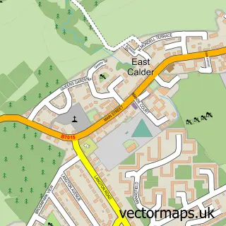
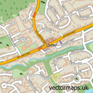
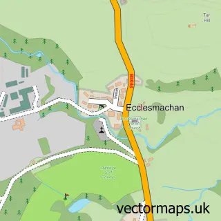
This Mid Calder street map is a detailed vector street map covering a 750m x 750m area. Select a larger area to create and download your own vector street map of Mid Calder.
The 750-metre map sample for Mid Calder covers 135 mapped buildings and approximately 9.5 km of road detail, of which 12 named roads are named. The immediate area includes 5 GP surgeries within 2 miles, 1 pub and 11 MOT stations within 2 miles. The wider area around Mid Calder features 2 tourism points of interest, 5 food and drink venues and 1 hotel. To create a larger or custom map of Mid Calder, the map builder lets you define your own coverage area and download editable SVG, PDF and PNG files.
Create a larger editable map of Mid Calder
Choose any area you need and generate a high-quality vector map instantly. Perfect for print, planning, design, business and personal use.

This Mid Calder street map in West Lothian is available as downloadable SVG, PDF and PNG map files, or as a printed map for planning, business, display, education, local information and design work. You can also create a larger custom map area using the map selector.
What this Mid Calder map sample shows
Mid Calder lies within West Lothian parish, part of East Livingston And East Calder ward in the West Lothian local authority area. The postcode geography for this area includes the EH postcode area, the EH53 postcode district and the EH53 0 postcode sector. Residents fall under the Lothian for NHS services.
Local features near Mid Calder
Within 2 milesAmenities and services in and around Mid Calder.
Administrative and postcode information for Mid Calder
Mid Calder lies within West Lothian parish, part of East Livingston And East Calder ward in the West Lothian local authority area. The postcode geography for this area includes the EH postcode area, the EH53 postcode district and the EH53 0 postcode sector. Residents fall under the Lothian for NHS services.
Nearby street map samples around Mid Calder

More street maps in West Lothian
750 metre map area coverage
Boundary, postcode and point of interest information for the 750m x 750m rectangle centred on this sample map.
Boundaries containing map centre
Constituency: Livingston Co Const
District: West Lothian
Icb: Lothian
Postcode District: EH53
Postcode Sector: EH53 0
Ward: East Livingston and East Calder Ward
Nearby boundaries intersecting sample
Postcode District: EH54
Postcode Sector: EH54 5
Postcode coverage
POI category counts
Beauty Salon: 5
Church Cathedral: 3
Restaurant: 3
Pizza Restaurant: 2
Shipping Center: 2
Adult Education: 1
Architectural Designer: 1
Asian Restaurant: 1
Bakery: 1
Bar: 1
Sample points of interest
- Mid Calder Community Education Association
- Watson John Architectural Consultants
- Calder Villa Takeaway
- Wallace Mill Pantry
- The Tapshop
- Antalya Barbers
- Beceri
- Faces by Erinn
- Glowup.hair.studio
- Julie Harris Beauty
- Milk Hairdressing
- Papillon
Create a larger editable map of Mid Calder
This sample shows only a 750 metre area. To create a larger map of Mid Calder, use our map builder to choose your own coverage area, add titles and download editable SVG, PDF and PNG files.
Create a custom map of Mid Calder