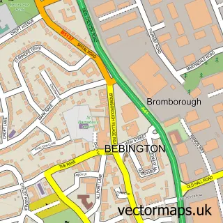
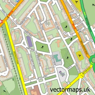
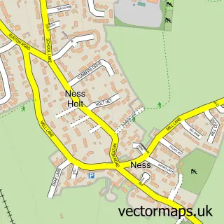
This Eastham Village street map is a detailed vector street map covering a 750m x 750m area. Select a larger area to create and download your own vector street map of Eastham Village.
The 750-metre map sample for Eastham Village covers 303 mapped buildings and approximately 16.0 km of road detail, of which 20 named roads are named. The immediate area includes 2 GP surgeries within 2 miles, 1 pub and 1 MOT station, with 8 within 2 miles. The wider area around Eastham Village features 3 tourism points of interest and 4 food and drink venues. To create a larger or custom map of Eastham Village, the map builder lets you define your own coverage area and download editable SVG, PDF and PNG files.
Create a larger editable map of Eastham Village
Choose any area you need and generate a high-quality vector map instantly. Perfect for print, planning, design, business and personal use.

This Eastham Village street map in Merseyside is available as downloadable SVG, PDF and PNG map files, or as a printed map for planning, business, display, education, local information and design work. You can also create a larger custom map area using the map selector.
What this Eastham Village map sample shows
Eastham Village lies within Wirral District (B) parish, part of Eastham ward in the Wirral District (B) local authority area. The postcode geography for this area includes the CH postcode area, the CH62 postcode district and the CH62 0 postcode sector. Residents fall under the Nhs Cheshire And Merseyside Integrated Care Board for NHS services.
Local features near Eastham Village
Within 2 milesAmenities and services in and around Eastham Village.
Administrative and postcode information for Eastham Village
The local authority covering Eastham Village is Wirral District (B), within the county of Merseyside. The settlement lies within Eastham ward and Wirral District (B) civil parish. The CH62 postcode district and CH62 0 postcode sector serve the immediate area. NHS provision in the area is delivered through Wirral University Teaching Hospital Nhs Foundation Trust.
Nearby street map samples around Eastham Village

More street maps in Merseyside
750 metre map area coverage
Boundary, postcode and point of interest information for the 750m x 750m rectangle centred on this sample map.
Boundaries containing map centre
Constituency: Ellesmere Port and Bromborough Boro Const
District: Wirral District (B)
Icb: NHS Cheshire and Merseyside ICB
Police Force: merseyside
Postcode District: CH62
Postcode Sector: CH62 0
Ward: Eastham Ward
Nearby boundaries intersecting sample
Postcode Sector: CH62 8, CH62 9
Postcode coverage
POI category counts
Martial Arts Club: 5
Hair Salon: 4
Legal Services: 4
Beauty And Spa: 3
Financial Service: 3
Accountant: 2
Anglican Church: 2
Automotive Repair: 2
Beauty Salon: 2
Cafe: 2
Sample points of interest
- KLAS Accountants Ltd
- Stocktake UK
- Real World Marketing
- St Mary the Blessed Virgin
- St Mary's Church
- Autosave
- Carlett Park Garage
- NatWest
- BeerShop Eastham
- Prestige Barbers
- Epic-Dermis skin clinic
- Sculpted by Kate
Create a larger editable map of Eastham Village
This sample shows only a 750 metre area. To create a larger map of Eastham Village, use our map builder to choose your own coverage area, add titles and download editable SVG, PDF and PNG files.
Create a custom map of Eastham Village