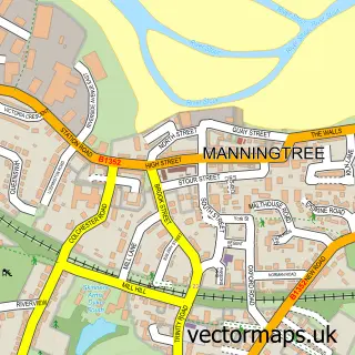
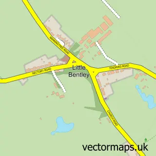
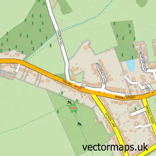
This Great Bromley street map is a detailed vector street map covering a 750m x 750m area. Select a larger area to create and download your own vector street map of Great Bromley.
The 750-metre map sample for Great Bromley covers 98 mapped buildings and approximately 9.0 km of road detail, of which 8 named roads are named. The immediate area includes 1 school and 1 pub. The wider area around Great Bromley features 1 food and drink venue. To create a larger or custom map of Great Bromley, the map builder lets you define your own coverage area and download editable SVG, PDF and PNG files.
Create a larger editable map of Great Bromley
Choose any area you need and generate a high-quality vector map instantly. Perfect for print, planning, design, business and personal use.

This Great Bromley street map in Essex is available as downloadable SVG, PDF and PNG map files, or as a printed map for planning, business, display, education, local information and design work. You can also create a larger custom map area using the map selector.
What this Great Bromley map sample shows
Great Bromley lies within Great Bromley Cp parish, part of Alresford & Elmstead ward in the Tendring District local authority area. The postcode geography for this area includes the CO postcode area, the CO7 postcode district and the CO7 7 postcode sector. Residents fall under the Nhs Suffolk And North East Essex Integrated Care Board for NHS services.
Local features near Great Bromley
Within 2 milesAmenities and services in and around Great Bromley.
Administrative and postcode information for Great Bromley
The local authority covering Great Bromley is Tendring District, within the county of Essex. The settlement lies within Alresford & Elmstead ward and Great Bromley Cp civil parish. The CO7 postcode district and CO7 7 postcode sector serve the immediate area. NHS provision in the area is delivered through East Suffolk And North Essex Nhs Foundation Trust.
Nearby street map samples around Great Bromley

More street maps in Essex
750 metre map area coverage
Boundary, postcode and point of interest information for the 750m x 750m rectangle centred on this sample map.
Boundaries containing map centre
Constituency: Harwich and North Essex Co Const
County: Essex County
District: Tendring District
Icb: NHS Essex ICB
Parish: Great Bromley CP
Police Force: essex
Postcode District: CO7
Postcode Sector: CO7 7
Ward: Alresford & Elmstead Ward
Nearby boundaries intersecting sample
No additional intersecting boundaries found.
Postcode coverage
POI category counts
Elementary School: 2
Anglican Church: 1
Brewery: 1
Caterer: 1
Church Cathedral: 1
Disability Services And Support Organization: 1
Education: 1
Engine Repair Service: 1
Grocery Store: 1
Martial Arts Club: 1
Sample points of interest
- St. George the Martyr, Great Bromley
- Sticklegs Brewery
- Patisserie4u
- St Georges Church
- Essex Stairlifts
- Little Dragons Pre-School Great Bromley & Frating
- St Georges CofE Primary School
- St Georges CofE Primary School
- P S Plant Services Ltd.
- Primrose Pork
- Adrenaline Martial Arts - Great Bromley
- Great Bromley War Memorial
Create a larger editable map of Great Bromley
This sample shows only a 750 metre area. To create a larger map of Great Bromley, use our map builder to choose your own coverage area, add titles and download editable SVG, PDF and PNG files.
Create a custom map of Great Bromley