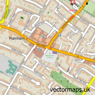
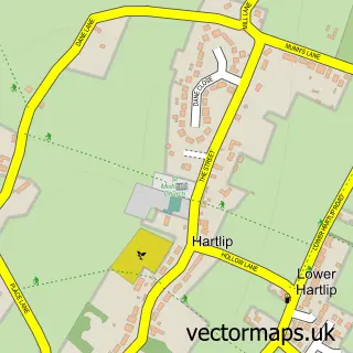
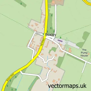
This Hempstead street map is a detailed vector street map covering a 750m x 750m area. Select a larger area to create and download your own vector street map of Hempstead.
The 750-metre map sample for Hempstead covers 514 mapped buildings and approximately 20.0 km of road detail, of which 28 named roads are named. The immediate area includes 1 school, 13 GP surgeries within 2 miles, 1 pub and 17 MOT stations within 2 miles. The wider area around Hempstead features 1 tourism point of interest and 3 food and drink venues. To create a larger or custom map of Hempstead, the map builder lets you define your own coverage area and download editable SVG, PDF and PNG files.
Create a larger editable map of Hempstead
Choose any area you need and generate a high-quality vector map instantly. Perfect for print, planning, design, business and personal use.

This Hempstead street map in Kent is available as downloadable SVG, PDF and PNG map files, or as a printed map for planning, business, display, education, local information and design work. You can also create a larger custom map area using the map selector.
What this Hempstead map sample shows
Hempstead lies within Medway (B) parish, part of Lordswood And Capstone ward in the Medway (B) local authority area. The postcode geography for this area includes the ME postcode area, the ME7 postcode district and the ME7 3 postcode sector. Residents fall under the Nhs Kent And Medway Integrated Care Board for NHS services.
Local features near Hempstead
Within 2 milesAmenities and services in and around Hempstead.
Administrative and postcode information for Hempstead
Hempstead lies within Medway (B) parish, part of Lordswood And Capstone ward in the Medway (B) local authority area. The postcode geography for this area includes the ME postcode area, the ME7 postcode district and the ME7 3 postcode sector. Residents fall under the Nhs Kent And Medway Integrated Care Board for NHS services.
Nearby street map samples around Hempstead

More street maps in Kent
750 metre map area coverage
Boundary, postcode and point of interest information for the 750m x 750m rectangle centred on this sample map.
Boundaries containing map centre
Constituency: Gillingham and Rainham Boro Const
District: Medway (B)
Icb: NHS Kent and Medway ICB
Police Force: kent
Postcode District: ME7
Postcode Sector: ME7 3
Ward: Hempstead & Wigmore Ward
Nearby boundaries intersecting sample
Constituency: Chatham and Aylesford Co Const
Ward: Lordswood & Walderslade Ward
Postcode coverage
POI category counts
Beauty Salon: 6
Preschool: 4
Bridal Shop: 3
Medical Center: 3
Doctor: 2
Education: 2
Elementary School: 2
Home Service: 2
Key And Locksmith: 2
Scout Hall: 2
Sample points of interest
- Hempstead: All Saints'
- Bayleaf Restaurant
- The Cooperative Food (BF) Hempstead
- Divine Cakes LLP
- Chapter 22 Aesthetics
- Clobo's Salon
- Flaunt Beauty
- Jade Ruby Beauty
- Shellee at Salon 31
- Strand Designs Hair and Beauty co
- Pennies from Heaven Designs
- Wedding Favours Ltd.
Create a larger editable map of Hempstead
This sample shows only a 750 metre area. To create a larger map of Hempstead, use our map builder to choose your own coverage area, add titles and download editable SVG, PDF and PNG files.
Create a custom map of Hempstead