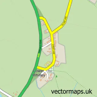
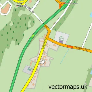
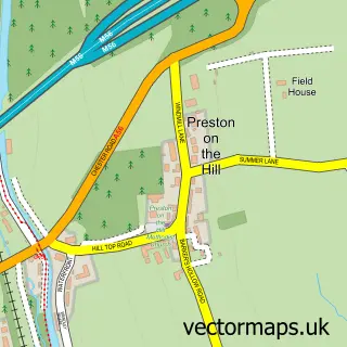
This Higher Whitley street map is a detailed vector street map covering a 750m x 750m area. Select a larger area to create and download your own vector street map of Higher Whitley.
The 750-metre map sample for Higher Whitley covers 74 mapped buildings and approximately 7.9 km of road detail, of which 5 named roads are named. The immediate area includes 1 school, 1 GP surgery within 2 miles and 1 MOT station within 2 miles. To create a larger or custom map of Higher Whitley, the map builder lets you define your own coverage area and download editable SVG, PDF and PNG files.
Create a larger editable map of Higher Whitley
Choose any area you need and generate a high-quality vector map instantly. Perfect for print, planning, design, business and personal use.

This Higher Whitley street map in Cheshire is available as downloadable SVG, PDF and PNG map files, or as a printed map for planning, business, display, education, local information and design work. You can also create a larger custom map area using the map selector.
What this Higher Whitley map sample shows
Higher Whitley lies within Whitley Cp parish, part of Marbury ward in the Cheshire West And Chester (B) local authority area. The postcode geography for this area includes the WA postcode area, the WA4 postcode district and the WA4 4 postcode sector. Residents fall under the Nhs Cheshire And Merseyside Integrated Care Board for NHS services.
Local features near Higher Whitley
Within 2 milesAmenities and services in and around Higher Whitley.
Administrative and postcode information for Higher Whitley
Higher Whitley lies within Whitley Cp parish, part of Marbury ward in the Cheshire West And Chester (B) local authority area. The postcode geography for this area includes the WA postcode area, the WA4 postcode district and the WA4 4 postcode sector. Residents fall under the Nhs Cheshire And Merseyside Integrated Care Board for NHS services.
Nearby street map samples around Higher Whitley

More street maps in Cheshire
750 metre map area coverage
Boundary, postcode and point of interest information for the 750m x 750m rectangle centred on this sample map.
Boundaries containing map centre
Constituency: Tatton Co Const
District: Cheshire West and Chester (B)
Icb: NHS Cheshire and Merseyside ICB
Parish: Whitley CP
Police Force: cheshire
Postcode District: WA4
Postcode Sector: WA4 4
Ward: Marbury Ward
Nearby boundaries intersecting sample
No additional intersecting boundaries found.
Postcode coverage
POI category counts
Art Restoration Service: 1
Automotive Repair: 1
Contractor: 1
Elementary School: 1
Hvac Services: 1
Industrial Equipment: 1
Interior Design: 1
It Service And Computer Repair: 1
Kitchen And Bath: 1
Marketing Agency: 1
Sample points of interest
- Williams Antique Furniture Restorers
- Wiper Technik
- The Kitchen Respray Group
- Whitley Village School
- 4 Seasons Air Conditioning
- Cheshire Farm Machinery
- Emmie B Interiors
- Computer Disposals
- Kitchen Respray Northwest
- Yellow Spider Media Ltd.
- DOVE Architecture and Interior Design
- M Y Cheshire P T
Create a larger editable map of Higher Whitley
This sample shows only a 750 metre area. To create a larger map of Higher Whitley, use our map builder to choose your own coverage area, add titles and download editable SVG, PDF and PNG files.
Create a custom map of Higher Whitley