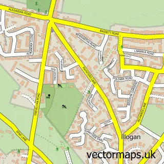
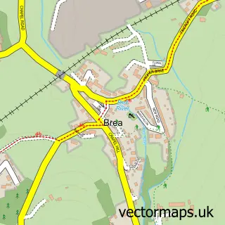
This Illogan Highway street map is a detailed vector street map covering a 750m x 750m area. Select a larger area to create and download your own vector street map of Illogan Highway.
The 750-metre map sample for Illogan Highway covers 411 mapped buildings and approximately 14.5 km of road detail, of which 20 named roads are named. The immediate area includes 1 school, 3 GP surgeries within 2 miles, 2 pubs and 1 MOT station, with 19 within 2 miles. The wider area around Illogan Highway features 1 tourism point of interest, 6 food and drink venues and 1 hotel. To create a larger or custom map of Illogan Highway, the map builder lets you define your own coverage area and download editable SVG, PDF and PNG files.
Create a larger editable map of Illogan Highway
Choose any area you need and generate a high-quality vector map instantly. Perfect for print, planning, design, business and personal use.

This Illogan Highway street map in Cornwall is available as downloadable SVG, PDF and PNG map files, or as a printed map for planning, business, display, education, local information and design work. You can also create a larger custom map area using the map selector.
What this Illogan Highway map sample shows
Illogan Highway lies within Carn Brea Cp parish, part of Pool And Tehidy ward in the Cornwall local authority area. The postcode geography for this area includes the TR postcode area, the TR15 postcode district and the TR15 3 postcode sector. Residents fall under the Nhs Cornwall And The Isles Of Scilly Integrated Care Board for NHS services.
Local features near Illogan Highway
Within 2 milesAmenities and services in and around Illogan Highway.
Administrative and postcode information for Illogan Highway
Illogan Highway lies within Carn Brea Cp parish, part of Pool And Tehidy ward in the Cornwall local authority area. The postcode geography for this area includes the TR postcode area, the TR15 postcode district and the TR15 3 postcode sector. Residents fall under the Nhs Cornwall And The Isles Of Scilly Integrated Care Board for NHS services.
Nearby street map samples around Illogan Highway

More street maps in Cornwall
750 metre map area coverage
Boundary, postcode and point of interest information for the 750m x 750m rectangle centred on this sample map.
Boundaries containing map centre
Constituency: Camborne and Redruth Co Const
District: Cornwall
Icb: NHS Cornwall and the Isles of Scilly ICB
Parish: Carn Brea CP
Police Force: devon and cornwall
Postcode District: TR15
Postcode Sector: TR15 3
Nearby boundaries intersecting sample
No additional intersecting boundaries found.
Postcode coverage
POI category counts
Building Supply Store: 7
Beauty Salon: 5
Professional Services: 5
Automotive Parts And Accessories: 4
Automotive Repair: 4
Pet Store: 4
Appliance Store: 3
Freight And Cargo Service: 3
Industrial Equipment: 3
Package Locker: 3
Sample points of interest
- Mill Signs
- CEF
- City Electrical Factors Ltd. (CEF)
- Moor To Sea Services
- Kynance Cove
- Cash in and out machine Morrisons Supermarket
- GK Electronics
- HSS Hire
- Elite Automotive SW Ltd
- Euroglass Automotive Glazing
- Veedubmachine Ltd.
- veedubmachine.co.uk
Create a larger editable map of Illogan Highway
This sample shows only a 750 metre area. To create a larger map of Illogan Highway, use our map builder to choose your own coverage area, add titles and download editable SVG, PDF and PNG files.
Create a custom map of Illogan Highway