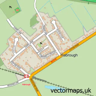
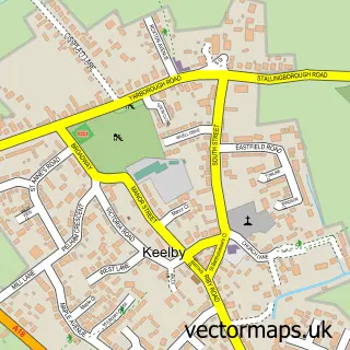
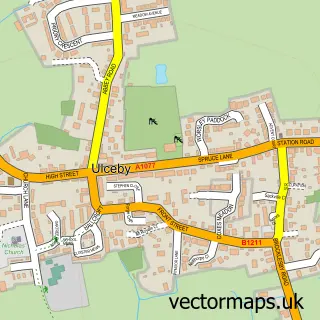
This Immingham street map is a detailed vector street map covering a 750m x 750m area. Select a larger area to create and download your own vector street map of Immingham.
The 750-metre map sample for Immingham covers 525 mapped buildings and approximately 15.5 km of road detail, of which 32 named roads are named. The immediate area includes 2 primary schools and 1 secondary school, 1 GP surgery within 2 miles and 8 MOT stations within 2 miles. The wider area around Immingham features 2 tourism points of interest, 3 food and drink venues and 1 hotel. To create a larger or custom map of Immingham, the map builder lets you define your own coverage area and download editable SVG, PDF and PNG files.
Create a larger editable map of Immingham
Choose any area you need and generate a high-quality vector map instantly. Perfect for print, planning, design, business and personal use.

This Immingham street map in Lincolnshire is available as downloadable SVG, PDF and PNG map files, or as a printed map for planning, business, display, education, local information and design work. You can also create a larger custom map area using the map selector.
What this Immingham map sample shows
Immingham lies within Immingham Cp parish, part of Immingham ward in the North East Lincolnshire (B) local authority area. The postcode geography for this area includes the DN postcode area, the DN40 postcode district and the DN40 1 postcode sector. Residents fall under the Nhs Humber And North Yorkshire Integrated Care Board for NHS services.
Local features near Immingham
Within 2 milesAmenities and services in and around Immingham.
Administrative and postcode information for Immingham
The local authority covering Immingham is North East Lincolnshire (B), within the county of Lincolnshire. The settlement lies within Immingham ward and Immingham Cp civil parish. The DN40 postcode district and DN40 1 postcode sector serve the immediate area. NHS provision in the area is delivered through Northern Lincolnshire And Goole Nhs Foundation Trust.
Nearby street map samples around Immingham

More street maps in Lincolnshire
750 metre map area coverage
Boundary, postcode and point of interest information for the 750m x 750m rectangle centred on this sample map.
Boundaries containing map centre
Constituency: Brigg and Immingham Co Const
District: North East Lincolnshire (B)
Icb: NHS Humber and North Yorkshire ICB
Parish: Immingham CP
Police Force: humberside
Postcode District: DN40
Postcode Sector: DN40 2
Ward: Immingham Ward
Nearby boundaries intersecting sample
Postcode Sector: DN40 1
Postcode coverage
POI category counts
Discount Store: 5
Supermarket: 4
Sandwich Shop: 3
Bank Credit Union: 2
Beauty Salon: 2
Betting Center: 2
Church Cathedral: 2
Community Services Non Profits: 2
Education: 2
Elementary School: 2
Sample points of interest
- Immingham
- Lloyds Bank
- NatWest
- Yorkshire Bank
- EDEN Beauty Tanning and Fitness
- Glow Up Ltd
- Betfred
- Coral
- Velo-Tool
- Coral
- Sandham's Quality Meats
- The Kiddies Cafe
Create a larger editable map of Immingham
This sample shows only a 750 metre area. To create a larger map of Immingham, use our map builder to choose your own coverage area, add titles and download editable SVG, PDF and PNG files.
Create a custom map of Immingham