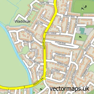
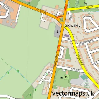
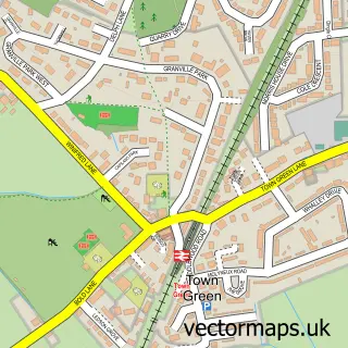
This Kirkby street map is a detailed vector street map covering a 750m x 750m area. Select a larger area to create and download your own vector street map of Kirkby.
The 750-metre map sample for Kirkby covers 114 mapped buildings and approximately 16.8 km of road detail, of which 29 named roads are named. The immediate area includes 1 school, 1 GP surgery, with 7 within 2 miles, 4 pubs and 10 MOT stations within 2 miles. The wider area around Kirkby features 3 tourism points of interest and 11 food and drink venues. To create a larger or custom map of Kirkby, the map builder lets you define your own coverage area and download editable SVG, PDF and PNG files.
Create a larger editable map of Kirkby
Choose any area you need and generate a high-quality vector map instantly. Perfect for print, planning, design, business and personal use.

This Kirkby street map in Merseyside is available as downloadable SVG, PDF and PNG map files, or as a printed map for planning, business, display, education, local information and design work. You can also create a larger custom map area using the map selector.
What this Kirkby map sample shows
Kirkby lies within Knowsley District (B) parish, part of Northwood ward in the Knowsley District (B) local authority area. The postcode geography for this area includes the L postcode area, the L33 postcode district and the L33 8 postcode sector. Residents fall under the Nhs Cheshire And Merseyside Integrated Care Board for NHS services.
Local features near Kirkby
Within 2 milesAmenities and services in and around Kirkby.
Administrative and postcode information for Kirkby
The local authority covering Kirkby is Knowsley District (B), within the county of Merseyside. The settlement lies within Northwood ward and Knowsley District (B) civil parish. The L33 postcode district and L33 8 postcode sector serve the immediate area. NHS provision in the area is delivered through Liverpool University Hospitals Nhs Foundation Trust.
Nearby street map samples around Kirkby

More street maps in Merseyside
750 metre map area coverage
Boundary, postcode and point of interest information for the 750m x 750m rectangle centred on this sample map.
Boundaries containing map centre
Constituency: Knowsley Boro Const
District: Knowsley District (B)
Icb: NHS Cheshire and Merseyside ICB
Police Force: merseyside
Postcode District: L32
Postcode Sector: L32 8
Ward: Whitefield Ward
Nearby boundaries intersecting sample
Postcode District: L33
Postcode Sector: L32 0, L32 1, L32 5, L32 9, L33 0, L33 8
Ward: Cherryfield Ward, Northwood Ward
Postcode coverage
POI category counts
Clothing Store: 7
Dentist: 5
Fast Food Restaurant: 5
Coffee Shop: 4
Discount Store: 4
Gym: 4
Pub: 4
Atms: 3
Bank Credit Union: 3
Banks: 3
Sample points of interest
- Kirkby Gallery & Prescot Museum
- Lazer Electrics
- Cash in and out machine Morrisons Supermarket
- Cashpoint® 145 Cherryfield Drive
- PayPoint
- Chris' mobile valeting
- Nes Solar Ltd.
- Greenhalghs Bakery
- Greggs
- Celebrations
- Barclays Bank - Kirkby
- Lloyds Bank
Create a larger editable map of Kirkby
This sample shows only a 750 metre area. To create a larger map of Kirkby, use our map builder to choose your own coverage area, add titles and download editable SVG, PDF and PNG files.
Create a custom map of Kirkby