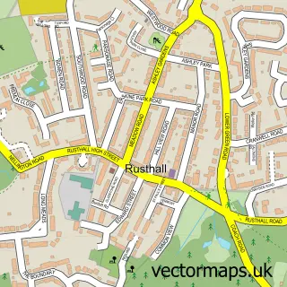
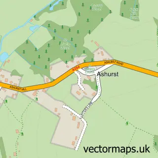
This Langton Green street map is a detailed vector street map covering a 750m x 750m area. Select a larger area to create and download your own vector street map of Langton Green.
The 750-metre map sample for Langton Green covers 356 mapped buildings and approximately 10.8 km of road detail, of which 27 named roads are named. The immediate area includes 2 GP surgeries within 2 miles and 1 MOT station within 2 miles. The wider area around Langton Green features 1 campsite within 2 miles. To create a larger or custom map of Langton Green, the map builder lets you define your own coverage area and download editable SVG, PDF and PNG files.
Create a larger editable map of Langton Green
Choose any area you need and generate a high-quality vector map instantly. Perfect for print, planning, design, business and personal use.

This Langton Green street map in Kent is available as downloadable SVG, PDF and PNG map files, or as a printed map for planning, business, display, education, local information and design work. You can also create a larger custom map area using the map selector.
What this Langton Green map sample shows
Langton Green lies within Speldhurst Cp parish, part of Speldhurst And Bidborough ward in the Tunbridge Wells District (B) local authority area. The postcode geography for this area includes the TN postcode area, the TN3 postcode district and the TN3 0 postcode sector. Residents fall under the Nhs Kent And Medway Integrated Care Board for NHS services.
Local features near Langton Green
Within 2 milesAmenities and services in and around Langton Green.
Administrative and postcode information for Langton Green
The local authority covering Langton Green is Tunbridge Wells District (B), within the county of Kent. The settlement lies within Speldhurst And Bidborough ward and Speldhurst Cp civil parish. The TN3 postcode district and TN3 0 postcode sector serve the immediate area. NHS provision in the area is delivered through Maidstone And Tunbridge Wells Nhs Trust.
Nearby street map samples around Langton Green


More street maps in Kent
750 metre map area coverage
Boundary, postcode and point of interest information for the 750m x 750m rectangle centred on this sample map.
Boundaries containing map centre
Constituency: Tunbridge Wells Co Const
County: Kent County
District: Tunbridge Wells District (B)
Icb: NHS Kent and Medway ICB
Parish: Speldhurst CP
Police Force: kent
Postcode District: TN3
Postcode Sector: TN3 0
Ward: Rusthall & Speldhurst Ward
Nearby boundaries intersecting sample
No additional intersecting boundaries found.
Postcode coverage
POI category counts
Building Supply Store: 2
Furniture Store: 2
Pilates Studio: 2
Atms: 1
Automotive Repair: 1
Bookstore: 1
Builders: 1
Cabinet Sales Service: 1
Carpenter: 1
Convenience Store: 1
Sample points of interest
- Esso Budgens
- Modus Engine Services
- Atlantic Books
- Bwb Building & Brickwork Contractors Ltd.
- Abbott Holliday Partnership
- Thomson Services Ltd
- Tom Goldsmith Joinery
- BWB Brickwork
- SPAR Tonbridge
- Haysden Liveries
- Louise Dean
- twhomestore
Create a larger editable map of Langton Green
This sample shows only a 750 metre area. To create a larger map of Langton Green, use our map builder to choose your own coverage area, add titles and download editable SVG, PDF and PNG files.
Create a custom map of Langton Green