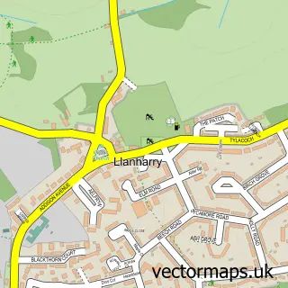
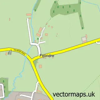
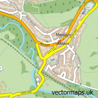
This Llanharan street map is a detailed vector street map covering a 750m x 750m area. Select a larger area to create and download your own vector street map of Llanharan.
The 750-metre map sample for Llanharan covers 253 mapped buildings and approximately 16.7 km of road detail, of which 27 named roads are named. The immediate area includes 1 school, 1 railway station, 1 GP surgery, with 2 within 2 miles and 2 pubs among other local services. The wider area around Llanharan features 3 food and drink venues and 1 hotel. To create a larger or custom map of Llanharan, the map builder lets you define your own coverage area and download editable SVG, PDF and PNG files.
Create a larger editable map of Llanharan
Choose any area you need and generate a high-quality vector map instantly. Perfect for print, planning, design, business and personal use.

This Llanharan street map in Mid Glamorgan is available as downloadable SVG, PDF and PNG map files, or as a printed map for planning, business, display, education, local information and design work. You can also create a larger custom map area using the map selector.
What this Llanharan map sample shows
Llanharan lies within Llanharan Community parish, part of Llanharan ward in the Rhondda Cynon Taf - Rhondda Cynon Taf local authority area. The postcode geography for this area includes the CF postcode area, the CF72 postcode district and the CF72 9 postcode sector. Residents fall under the Cwm Taf University Health Board for NHS services.
Local features near Llanharan
Within 2 milesAmenities and services in and around Llanharan.
Administrative and postcode information for Llanharan
The local authority covering Llanharan is Rhondda Cynon Taf - Rhondda Cynon Taf, within the county of Mid Glamorgan. The settlement lies within Llanharan ward and Llanharan Community civil parish. The CF72 postcode district and CF72 9 postcode sector serve the immediate area. NHS provision in the area is delivered through Cwm Taf Morgannwg University Health Board.
Nearby street map samples around Llanharan

More street maps in Mid Glamorgan
750 metre map area coverage
Boundary, postcode and point of interest information for the 750m x 750m rectangle centred on this sample map.
Boundaries containing map centre
Constituency: Pontypridd Co Const
District: Rhondda Cynon Taf - Rhondda Cynon Taf
Icb: Cwm Taf University
Parish: Llanharan Community
Police Force: south wales
Postcode District: CF72
Postcode Sector: CF72 9
Nearby boundaries intersecting sample
No additional intersecting boundaries found.
Postcode coverage
POI category counts
Amateur Sports Team: 2
Automotive Repair: 2
Beauty Salon: 2
Gas Station: 2
Gym: 2
Hair Salon: 2
Post Office: 2
Pub: 2
Train Station: 2
Antique Store: 1
Sample points of interest
- Llanharan RFC
- South Wales Warriors
- Llanharan Community Shop
- Blandy Jenkins Archers
- Llanharan Cenotaph
- Llaharan Service Station (Protected), Llanharan
- Howling Coyoteez
- SLM Tyres and Autos
- Carmel Baptist Church
- Turberville
- 01’ Studio
- Haus of Pixiee
Create a larger editable map of Llanharan
This sample shows only a 750 metre area. To create a larger map of Llanharan, use our map builder to choose your own coverage area, add titles and download editable SVG, PDF and PNG files.
Create a custom map of Llanharan