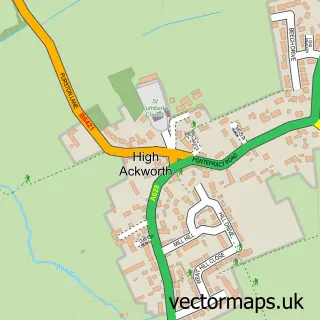
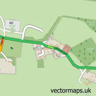
This Low Ackworth street map is a detailed vector street map covering a 750m x 750m area. Select a larger area to create and download your own vector street map of Low Ackworth.
The 750-metre map sample for Low Ackworth covers 282 mapped buildings and approximately 8.5 km of road detail, of which 17 named roads are named. The immediate area includes 1 school, 1 GP surgery within 2 miles and 4 MOT stations within 2 miles. To create a larger or custom map of Low Ackworth, the map builder lets you define your own coverage area and download editable SVG, PDF and PNG files.
Create a larger editable map of Low Ackworth
Choose any area you need and generate a high-quality vector map instantly. Perfect for print, planning, design, business and personal use.

This Low Ackworth street map in West Yorkshire is available as downloadable SVG, PDF and PNG map files, or as a printed map for planning, business, display, education, local information and design work. You can also create a larger custom map area using the map selector.
What this Low Ackworth map sample shows
Low Ackworth lies within Ackworth Cp parish, part of Ackworth, North Elmsall And Upton ward in the Wakefield District (B) local authority area. The postcode geography for this area includes the WF postcode area, the WF7 postcode district and the WF7 7 postcode sector. Residents fall under the Nhs West Yorkshire Integrated Care Board for NHS services.
Local features near Low Ackworth
Within 2 milesAmenities and services in and around Low Ackworth.
Administrative and postcode information for Low Ackworth
Low Ackworth lies within Ackworth Cp parish, part of Ackworth, North Elmsall And Upton ward in the Wakefield District (B) local authority area. The postcode geography for this area includes the WF postcode area, the WF7 postcode district and the WF7 7 postcode sector. Residents fall under the Nhs West Yorkshire Integrated Care Board for NHS services.
Nearby street map samples around Low Ackworth

More street maps in West Yorkshire
750 metre map area coverage
Boundary, postcode and point of interest information for the 750m x 750m rectangle centred on this sample map.
Boundaries containing map centre
Constituency: Normanton and Hemsworth Co Const
District: Wakefield District (B)
Icb: NHS West Yorkshire ICB
Parish: Ackworth CP
Police Force: west yorkshire
Postcode District: WF7
Postcode Sector: WF7 7
Ward: Ackworth, North Elmsall and Upton Ward
Nearby boundaries intersecting sample
No additional intersecting boundaries found.
Postcode coverage
POI category counts
Beauty Salon: 2
Community Center: 2
Advertising Agency: 1
Driving School: 1
Elementary School: 1
Flooring Contractors: 1
Grocery Store: 1
Professional Services: 1
Public Toilet: 1
Scout Hall: 1
Sample points of interest
- Visualcraft Limited
- Claire Durow Hairdressing
- Select Hair Studio
- Ackworth Community Hub
- Low Ackworth Community Centre
- Will Walker
- Ackworth Howard Church of England Junior and Infant School
- Floor Decor
- Today’s local Low Ackworth
- Hermes ParcelShop
- Patryk2703
- 1st Ackworth
Create a larger editable map of Low Ackworth
This sample shows only a 750 metre area. To create a larger map of Low Ackworth, use our map builder to choose your own coverage area, add titles and download editable SVG, PDF and PNG files.
Create a custom map of Low Ackworth