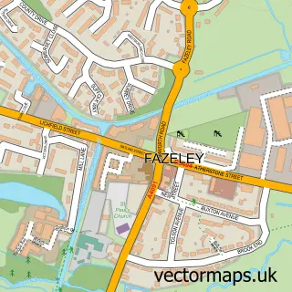
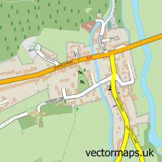
This Mile Oak street map is a detailed vector street map covering a 750m x 750m area. Select a larger area to create and download your own vector street map of Mile Oak.
The 750-metre map sample for Mile Oak covers 233 mapped buildings and approximately 23.8 km of road detail, of which 14 named roads are named. The immediate area includes 1 school, 6 GP surgeries within 2 miles and 1 MOT station, with 19 within 2 miles. The wider area around Mile Oak features 1 food and drink venue and 1 campsite within 2 miles. To create a larger or custom map of Mile Oak, the map builder lets you define your own coverage area and download editable SVG, PDF and PNG files.
Create a larger editable map of Mile Oak
Choose any area you need and generate a high-quality vector map instantly. Perfect for print, planning, design, business and personal use.

This Mile Oak street map in Staffordshire is available as downloadable SVG, PDF and PNG map files, or as a printed map for planning, business, display, education, local information and design work. You can also create a larger custom map area using the map selector.
What this Mile Oak map sample shows
Mile Oak lies within Fazeley Cp parish, part of Fazeley ward in the Lichfield District local authority area. The postcode geography for this area includes the B postcode area, the B78 postcode district and the B78 3 postcode sector. Residents fall under the Nhs Staffordshire And Stoke-On-Trent Integrated Care Board for NHS services.
Local features near Mile Oak
Within 2 milesAmenities and services in and around Mile Oak.
Administrative and postcode information for Mile Oak
The local authority covering Mile Oak is Lichfield District, within the county of Staffordshire. The settlement lies within Fazeley ward and Fazeley Cp civil parish. The B78 postcode district and B78 3 postcode sector serve the immediate area. NHS provision in the area is delivered through University Hospitals Birmingham Nhs Foundation Trust.
Nearby street map samples around Mile Oak


More street maps in Staffordshire
750 metre map area coverage
Boundary, postcode and point of interest information for the 750m x 750m rectangle centred on this sample map.
Boundaries containing map centre
Constituency: Tamworth Co Const
County: Staffordshire County
District: Lichfield District
Icb: NHS Black Country ICB
Parish: Fazeley CP
Police Force: staffordshire
Postcode District: B78
Postcode Sector: B78 3
Ward: Fazeley Ward
Nearby boundaries intersecting sample
No additional intersecting boundaries found.
Postcode coverage
POI category counts
Business Management Services: 3
Car Dealer: 3
Preschool: 3
Beauty And Spa: 2
Hair Salon: 2
Shipping Center: 2
Auto Detailing: 1
Building Supply Store: 1
Childrens Clothing Store: 1
Coffee Shop: 1
Sample points of interest
- Diamondshine Mobile Valeting
- Kim Elizabeth Beauty
- Linda's nails at Blush
- Classic Blinds
- Motability Scheme at LSH Mercedes-Benz of Tamworth
- Mr Moss
- Nisa Local
- LSH Auto UK Limited
- Mercedes-Benz of Tamworth
- Smart Tamworth
- Elsie May Bridal & Altered 4 U
- Costa Express
Create a larger editable map of Mile Oak
This sample shows only a 750 metre area. To create a larger map of Mile Oak, use our map builder to choose your own coverage area, add titles and download editable SVG, PDF and PNG files.
Create a custom map of Mile Oak