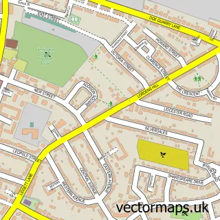
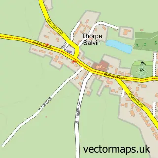
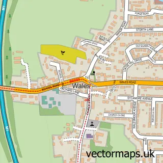
This North Anston street map is a detailed vector street map covering a 750m x 750m area. Select a larger area to create and download your own vector street map of North Anston.
The 750-metre map sample for North Anston covers 543 mapped buildings and approximately 22.8 km of road detail, of which 38 named roads are named. The immediate area includes 1 school, 1 GP surgery, 2 pubs and 8 MOT stations within 2 miles. The wider area around North Anston features 2 tourism points of interest and 3 food and drink venues. To create a larger or custom map of North Anston, the map builder lets you define your own coverage area and download editable SVG, PDF and PNG files.
Create a larger editable map of North Anston
Choose any area you need and generate a high-quality vector map instantly. Perfect for print, planning, design, business and personal use.

This North Anston street map in South Yorkshire is available as downloadable SVG, PDF and PNG map files, or as a printed map for planning, business, display, education, local information and design work. You can also create a larger custom map area using the map selector.
What this North Anston map sample shows
North Anston lies within North And South Anston Cp parish, part of Anston And Woodsetts ward in the Rotherham District (B) local authority area. The postcode geography for this area includes the S postcode area, the S25 postcode district and the S25 5 postcode sector. Residents fall under the Nhs South Yorkshire Integrated Care Board for NHS services.
Local features near North Anston
Within 2 milesAmenities and services in and around North Anston.
Administrative and postcode information for North Anston
North Anston lies within North And South Anston Cp parish, part of Anston And Woodsetts ward in the Rotherham District (B) local authority area. The postcode geography for this area includes the S postcode area, the S25 postcode district and the S25 5 postcode sector. Residents fall under the Nhs South Yorkshire Integrated Care Board for NHS services.
Nearby street map samples around North Anston

More street maps in South Yorkshire
750 metre map area coverage
Boundary, postcode and point of interest information for the 750m x 750m rectangle centred on this sample map.
Boundaries containing map centre
Constituency: Rother Valley Co Const
District: Rotherham District (B)
Icb: NHS South Yorkshire ICB
Parish: North and South Anston CP
Police Force: south yorkshire
Postcode District: S25
Postcode Sector: S25 4
Ward: Anston & Woodsetts Ward
Nearby boundaries intersecting sample
Postcode Sector: S25 5
Postcode coverage
POI category counts
Convenience Store: 6
Beauty Salon: 2
Community Center: 2
Contractor: 2
Doctor: 2
Financial Advising: 2
Fish And Chips Restaurant: 2
Food Delivery Service: 2
Park: 2
Pet Services: 2
Sample points of interest
- Charles Black Associates
- Plaxton
- Scotts Barber Shop North Anston
- Head Office Hair Salon
- KHB Semi Permanent Make Up
- Rachel Philips
- MICK McCALL Family Butcher
- Cafe Espresso
- Anston Chinese
- North Notts College
- Darnall Community Development Centre
- The Green Community well-being & Sports Academy
Create a larger editable map of North Anston
This sample shows only a 750 metre area. To create a larger map of North Anston, use our map builder to choose your own coverage area, add titles and download editable SVG, PDF and PNG files.
Create a custom map of North Anston