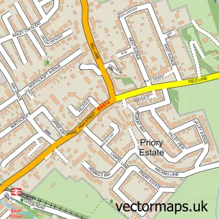
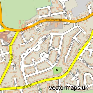
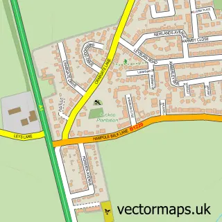
This North Elmsall street map is a detailed vector street map covering a 750m x 750m area. Select a larger area to create and download your own vector street map of North Elmsall.
The 750-metre map sample for North Elmsall covers 87 mapped buildings and approximately 12.3 km of road detail, of which 11 named roads are named. The immediate area includes 3 GP surgeries within 2 miles and 7 MOT stations within 2 miles. The wider area around North Elmsall features 1 tourism point of interest. To create a larger or custom map of North Elmsall, the map builder lets you define your own coverage area and download editable SVG, PDF and PNG files.
Create a larger editable map of North Elmsall
Choose any area you need and generate a high-quality vector map instantly. Perfect for print, planning, design, business and personal use.

This North Elmsall street map in West Yorkshire is available as downloadable SVG, PDF and PNG map files, or as a printed map for planning, business, display, education, local information and design work. You can also create a larger custom map area using the map selector.
What this North Elmsall map sample shows
North Elmsall lies within North Elmsall Cp parish, part of Ackworth, North Elmsall And Upton ward in the Wakefield District (B) local authority area. The postcode geography for this area includes the WF postcode area, the WF9 postcode district and the WF9 2 postcode sector. Residents fall under the Nhs West Yorkshire Integrated Care Board for NHS services.
Local features near North Elmsall
Within 2 milesAmenities and services in and around North Elmsall.
Administrative and postcode information for North Elmsall
North Elmsall lies within North Elmsall Cp parish, part of Ackworth, North Elmsall And Upton ward in the Wakefield District (B) local authority area. The postcode geography for this area includes the WF postcode area, the WF9 postcode district and the WF9 2 postcode sector. Residents fall under the Nhs West Yorkshire Integrated Care Board for NHS services.
Nearby street map samples around North Elmsall

More street maps in West Yorkshire
750 metre map area coverage
Boundary, postcode and point of interest information for the 750m x 750m rectangle centred on this sample map.
Boundaries containing map centre
Constituency: Normanton and Hemsworth Co Const
District: Wakefield District (B)
Icb: NHS West Yorkshire ICB
Parish: Upton and North Elmsall CP
Police Force: west yorkshire
Postcode District: WF9
Postcode Sector: WF9 2
Ward: Ackworth, North Elmsall and Upton Ward
Nearby boundaries intersecting sample
Parish: South Elmsall CP
Postcode Sector: WF9 1
Postcode coverage
POI category counts
Automotive Repair: 2
Anglican Church: 1
Automotive Dealer: 1
Carpet Cleaning: 1
Church Cathedral: 1
Landmark And Historical Building: 1
Pet Sitting: 1
Topic Publisher: 1
Used Car Dealer: 1
Sample points of interest
- St Margaret's Church
- A1 Car Sales
- New Lane Service Centre
- Upton Panel Beating
- Steve Scott Carpet Cleaning
- Saint Margarets Church
- North Elmsall
- Elmsall Kennels and Cattery
- Gosling Press
- R D A
Create a larger editable map of North Elmsall
This sample shows only a 750 metre area. To create a larger map of North Elmsall, use our map builder to choose your own coverage area, add titles and download editable SVG, PDF and PNG files.
Create a custom map of North Elmsall