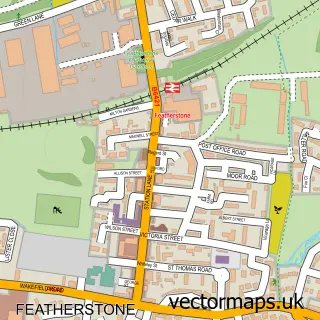
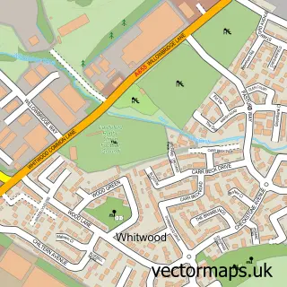
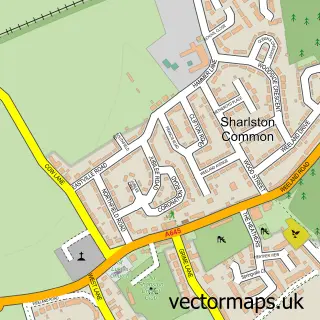
This North Featherstone street map is a detailed vector street map covering a 750m x 750m area. Select a larger area to create and download your own vector street map of North Featherstone.
The 750-metre map sample for North Featherstone covers 355 mapped buildings and approximately 14.4 km of road detail, of which 23 named roads are named. The immediate area includes 1 primary school and 1 secondary school, 4 GP surgeries within 2 miles, 2 pubs and 18 MOT stations within 2 miles. The wider area around North Featherstone features 3 food and drink venues. To create a larger or custom map of North Featherstone, the map builder lets you define your own coverage area and download editable SVG, PDF and PNG files.
Create a larger editable map of North Featherstone
Choose any area you need and generate a high-quality vector map instantly. Perfect for print, planning, design, business and personal use.

This North Featherstone street map in West Yorkshire is available as downloadable SVG, PDF and PNG map files, or as a printed map for planning, business, display, education, local information and design work. You can also create a larger custom map area using the map selector.
What this North Featherstone map sample shows
North Featherstone lies within Featherstone Cp parish, part of Featherstone ward in the Wakefield District (B) local authority area. The postcode geography for this area includes the WF postcode area, the WF7 postcode district and the WF7 6 postcode sector. Residents fall under the Nhs West Yorkshire Integrated Care Board for NHS services.
Local features near North Featherstone
Within 2 milesAmenities and services in and around North Featherstone.
Administrative and postcode information for North Featherstone
The local authority covering North Featherstone is Wakefield District (B), within the county of West Yorkshire. The settlement lies within Featherstone ward and Featherstone Cp civil parish. The WF7 postcode district and WF7 6 postcode sector serve the immediate area. NHS provision in the area is delivered through Mid Yorkshire Teaching Nhs Trust.
Nearby street map samples around North Featherstone

More street maps in West Yorkshire
750 metre map area coverage
Boundary, postcode and point of interest information for the 750m x 750m rectangle centred on this sample map.
Boundaries containing map centre
Constituency: Normanton and Hemsworth Co Const
District: Wakefield District (B)
Icb: NHS West Yorkshire ICB
Parish: Featherstone CP
Police Force: west yorkshire
Postcode District: WF7
Postcode Sector: WF7 6
Ward: Featherstone Ward
Nearby boundaries intersecting sample
Constituency: Pontefract, Castleford and Knottingley Co Const
Postcode District: WF8
Postcode Sector: WF8 4
Ward: Pontefract North Ward
Postcode coverage
POI category counts
Post Office: 3
Anglican Church: 2
Building Supply Store: 2
High School: 2
Pub: 2
Swimming Instructor: 2
Beauty And Spa: 1
Beauty Salon: 1
Bed And Breakfast: 1
Cafe: 1
Sample points of interest
- All Saints
- All Saints' Church
- On The Lash by Kayleigh
- Rose Garden Hair and beauty
- Rolands Croft Guest House
- ABC Shot Blasting
- Rackham Housefloors
- Featherstone Fillers
- Ckmetalcraft
- Best-one
- Parkfield Dog Park
- The Puppy Master
Create a larger editable map of North Featherstone
This sample shows only a 750 metre area. To create a larger map of North Featherstone, use our map builder to choose your own coverage area, add titles and download editable SVG, PDF and PNG files.
Create a custom map of North Featherstone