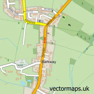
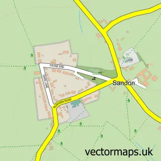
This Reed street map is a detailed vector street map covering a 750m x 750m area. Select a larger area to create and download your own vector street map of Reed.
The 750-metre map sample for Reed covers 122 mapped buildings and approximately 10.7 km of road detail, of which 10 named roads are named. The immediate area includes 1 school and 1 MOT station within 2 miles. To create a larger or custom map of Reed, the map builder lets you define your own coverage area and download editable SVG, PDF and PNG files.
Create a larger editable map of Reed
Choose any area you need and generate a high-quality vector map instantly. Perfect for print, planning, design, business and personal use.

This Reed street map in Hertfordshire is available as downloadable SVG, PDF and PNG map files, or as a printed map for planning, business, display, education, local information and design work. You can also create a larger custom map area using the map selector.
What this Reed map sample shows
Reed lies within Therfield Cp parish, part of Ermine ward in the North Hertfordshire District local authority area. The postcode geography for this area includes the SG postcode area, the SG8 postcode district and the SG8 8 postcode sector. Residents fall under the Nhs Cambridgeshire And Peterborough Integrated Care Board for NHS services.
Local features near Reed
Within 2 milesAmenities and services in and around Reed.
Administrative and postcode information for Reed
The local authority covering Reed is North Hertfordshire District, within the county of Hertfordshire. The settlement lies within Ermine ward and Therfield Cp civil parish. The SG8 postcode district and SG8 8 postcode sector serve the immediate area. NHS provision in the area is delivered through East And North Hertfordshire Nhs Trust.
Nearby street map samples around Reed


More street maps in Hertfordshire
750 metre map area coverage
Boundary, postcode and point of interest information for the 750m x 750m rectangle centred on this sample map.
Boundaries containing map centre
Constituency: North East Hertfordshire Co Const
County: Hertfordshire County
District: North Hertfordshire District
Icb: NHS Central East ICB
Parish: Reed CP
Police Force: hertfordshire
Postcode District: SG8
Postcode Sector: SG8 8
Ward: Ermine Ward
Nearby boundaries intersecting sample
No additional intersecting boundaries found.
Postcode coverage
POI category counts
Bar: 1
Community Center: 1
Elementary School: 1
Indian Restaurant: 1
It Service And Computer Repair: 1
Security Systems: 1
Sample points of interest
- The Cabinet at Reed
- Reed Village Hall
- Reed First School
- Spice Cabinet Reed
- Oakwood Business Systems
- Barry Dray Distribution
Create a larger editable map of Reed
This sample shows only a 750 metre area. To create a larger map of Reed, use our map builder to choose your own coverage area, add titles and download editable SVG, PDF and PNG files.
Create a custom map of Reed