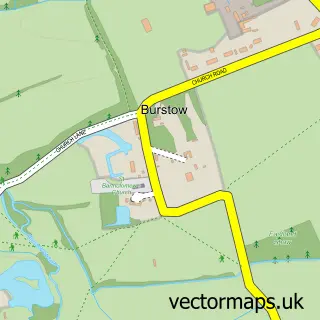
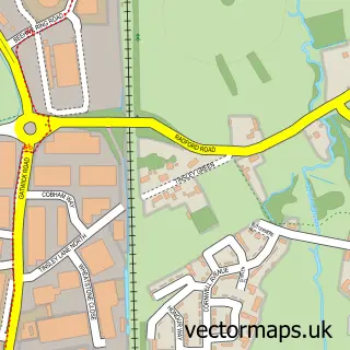
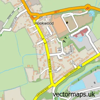
This Shipley Bridge street map is a detailed vector street map covering a 750m x 750m area. Select a larger area to create and download your own vector street map of Shipley Bridge.
The 750-metre map sample for Shipley Bridge covers 97 mapped buildings and approximately 11.0 km of road detail, of which 5 named roads are named. The immediate area includes 1 GP surgery within 2 miles, 2 pubs and 1 MOT station, with 18 within 2 miles. The wider area around Shipley Bridge features 3 food and drink venues. To create a larger or custom map of Shipley Bridge, the map builder lets you define your own coverage area and download editable SVG, PDF and PNG files.
Create a larger editable map of Shipley Bridge
Choose any area you need and generate a high-quality vector map instantly. Perfect for print, planning, design, business and personal use.

This Shipley Bridge street map in Surrey is available as downloadable SVG, PDF and PNG map files, or as a printed map for planning, business, display, education, local information and design work. You can also create a larger custom map area using the map selector.
What this Shipley Bridge map sample shows
Shipley Bridge lies within Burstow Cp parish, part of Burstow, Horne And Outwood ward in the Tandridge District local authority area. The postcode geography for this area includes the RH postcode area, the RH6 postcode district and the RH6 9 postcode sector. Residents fall under the Nhs Surrey Heartlands Integrated Care Board for NHS services.
Local features near Shipley Bridge
Within 2 milesAmenities and services in and around Shipley Bridge.
Administrative and postcode information for Shipley Bridge
The local authority covering Shipley Bridge is Tandridge District, within the county of Surrey. The settlement lies within Burstow, Horne And Outwood ward and Burstow Cp civil parish. The RH6 postcode district and RH6 9 postcode sector serve the immediate area. NHS provision in the area is delivered through Surrey And Sussex Healthcare Nhs Trust.
Nearby street map samples around Shipley Bridge

More street maps in Surrey
750 metre map area coverage
Boundary, postcode and point of interest information for the 750m x 750m rectangle centred on this sample map.
Boundaries containing map centre
Constituency: East Surrey Co Const
County: Surrey County
District: Tandridge District
Icb: NHS Surrey and Sussex ICB
Parish: Burstow CP
Police Force: surrey
Postcode District: RH6
Postcode Sector: RH6 9
Ward: Burstow, Horne & Outwood Ward
Nearby boundaries intersecting sample
Constituency: Crawley Boro Const
County: West Sussex County
District: Crawley District (B)
Police Force: sussex
Ward: Pound Hill North & Forge Wood Ward
Postcode coverage
POI category counts
Building Supply Store: 3
Personal Care Service: 3
Automotive Repair: 2
Pub: 2
Travel Services: 2
Accountant: 1
Automotive Parts And Accessories: 1
Cafe: 1
Chimney Sweep: 1
Contractor: 1
Sample points of interest
- FMP Payroll Services
- LMA Motorsport
- AJD Motors LTD
- Classic Car Repairs
- Granite Revolutions
- Homegrown Timber Rail
- P & B Services
- Project Cafe Horley
- Phoenix Building Products
- Sussex Paving Specialists
- Clemlec
- Car Finance Sussex
Create a larger editable map of Shipley Bridge
This sample shows only a 750 metre area. To create a larger map of Shipley Bridge, use our map builder to choose your own coverage area, add titles and download editable SVG, PDF and PNG files.
Create a custom map of Shipley Bridge