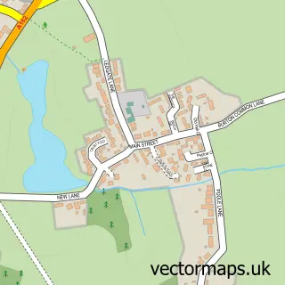
This South Milford street map is a detailed vector street map covering a 750m x 750m area. Select a larger area to create and download your own vector street map of South Milford.
The 750-metre map sample for South Milford covers 400 mapped buildings and approximately 13.1 km of road detail, of which 31 named roads are named. The immediate area includes 1 school, 1 GP surgery, with 2 within 2 miles, 2 pubs and 4 MOT stations within 2 miles. The wider area around South Milford features 2 tourism points of interest and 2 food and drink venues. To create a larger or custom map of South Milford, the map builder lets you define your own coverage area and download editable SVG, PDF and PNG files.
Create a larger editable map of South Milford
Choose any area you need and generate a high-quality vector map instantly. Perfect for print, planning, design, business and personal use.

This South Milford street map in North Yorkshire is available as downloadable SVG, PDF and PNG map files, or as a printed map for planning, business, display, education, local information and design work. You can also create a larger custom map area using the map selector.
What this South Milford map sample shows
South Milford lies within South Milford Cp parish, part of South Milford ward in the North Yorkshire local authority area. The postcode geography for this area includes the LS postcode area, the LS25 postcode district and the LS25 5 postcode sector. Residents fall under the Nhs Humber And North Yorkshire Integrated Care Board for NHS services.
Local features near South Milford
Within 2 milesAmenities and services in and around South Milford.
Administrative and postcode information for South Milford
The local authority covering South Milford is North Yorkshire, within the county of North Yorkshire. The settlement lies within South Milford ward and South Milford Cp civil parish. The LS25 postcode district and LS25 5 postcode sector serve the immediate area. NHS provision in the area is delivered through York And Scarborough Teaching Hospitals Nhs Foundation Trust.
Nearby street map samples around South Milford


More street maps in North Yorkshire
750 metre map area coverage
Boundary, postcode and point of interest information for the 750m x 750m rectangle centred on this sample map.
Boundaries containing map centre
Constituency: Selby Co Const
District: North Yorkshire
Icb: NHS Humber and North Yorkshire ICB
Parish: South Milford CP
Police Force: north yorkshire
Postcode District: LS25
Postcode Sector: LS25 5
Nearby boundaries intersecting sample
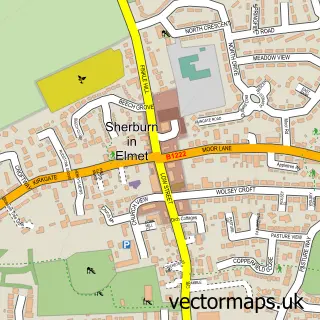
Parish: Sherburn in Elmet CP
Postcode Sector: LS25 6
Postcode coverage
POI category counts
Park: 2
Pub: 2
Bakery: 1
Beauty And Spa: 1
Beauty Salon: 1
Broadcasting Media Production: 1
Commercial Industrial: 1
Community Services Non Profits: 1
Construction Services: 1
Cricket Ground: 1
Sample points of interest
- Pink Flamingo Wedding Cakes
- Floosie Beauty + Lifestyle
- Petite Studios Salon
- NFD Productions Ltd
- CAIN Services Leeds Ltd
- South Milford Memorial Playing Fields Association
- Jtm Building
- South Milford Cricket Club
- Milford Aesthetics
- South Milford Surgery
- California Dog Field
- Paul Webster Approved Driving Instructor
Create a larger editable map of South Milford
This sample shows only a 750 metre area. To create a larger map of South Milford, use our map builder to choose your own coverage area, add titles and download editable SVG, PDF and PNG files.
Create a custom map of South Milford