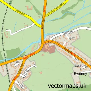
This St Brides Major street map is a detailed vector street map covering a 750m x 750m area. Select a larger area to create and download your own vector street map of St Brides Major.
The 750-metre map sample for St Brides Major covers 204 mapped buildings and approximately 14.5 km of road detail, of which 11 named roads are named. The immediate area includes 1 school and 3 pubs. The wider area around St Brides Major features 2 tourism points of interest and 4 food and drink venues. To create a larger or custom map of St Brides Major, the map builder lets you define your own coverage area and download editable SVG, PDF and PNG files.
Create a larger editable map of St Brides Major
Choose any area you need and generate a high-quality vector map instantly. Perfect for print, planning, design, business and personal use.

This St Brides Major street map in South Glamorgan is available as downloadable SVG, PDF and PNG map files, or as a printed map for planning, business, display, education, local information and design work. You can also create a larger custom map area using the map selector.
What this St Brides Major map sample shows
St Brides Major lies within St. Bride's Major Community parish, part of St. Bride's Major ward in the Bro Morgannwg - The Vale Of Glamorgan local authority area. The postcode geography for this area includes the CF postcode area, the CF32 postcode district and the CF32 0 postcode sector. Residents fall under the Cardiff And Vale University Health Board for NHS services.
Local features near St Brides Major
Within 2 milesAmenities and services in and around St Brides Major.
Administrative and postcode information for St Brides Major
St Brides Major lies within St. Bride's Major Community parish, part of St. Bride's Major ward in the Bro Morgannwg - The Vale Of Glamorgan local authority area. The postcode geography for this area includes the CF postcode area, the CF32 postcode district and the CF32 0 postcode sector. Residents fall under the Cardiff And Vale University Health Board for NHS services.
Nearby street map samples around St Brides Major


More street maps in South Glamorgan
750 metre map area coverage
Boundary, postcode and point of interest information for the 750m x 750m rectangle centred on this sample map.
Boundaries containing map centre
Constituency: Vale of Glamorgan Co Const
District: Bro Morgannwg - the Vale of Glamorgan
Icb: Cardiff and Vale University
Parish: St. Bride's Major Community
Police Force: south wales
Postcode District: CF32
Postcode Sector: CF32 0
Nearby boundaries intersecting sample
No additional intersecting boundaries found.
Postcode coverage
POI category counts
Church Cathedral: 3
Convenience Store: 3
Pub: 3
Bed And Breakfast: 2
Advertising Agency: 1
Beauty Salon: 1
Bicycle Shop: 1
Cafe: 1
Campground: 1
Dairy Farm: 1
Sample points of interest
- Aurora Digital Marketing
- Coast Hair and Beauty
- Ewenny farm guest house
- St Bridgets Farmhouse B&B
- Al's Bike Shed
- The Great White
- Pool Farm Camping
- Parish Church of St Bridget
- St Bridgets Church, St Brides Major
- The Parish of Ewenny With St Brides Major
- SPAR
- St Brides Major Village Shop & Post Office
Create a larger editable map of St Brides Major
This sample shows only a 750 metre area. To create a larger map of St Brides Major, use our map builder to choose your own coverage area, add titles and download editable SVG, PDF and PNG files.
Create a custom map of St Brides Major