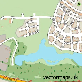
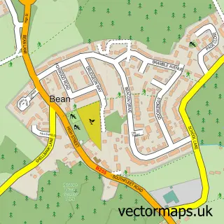
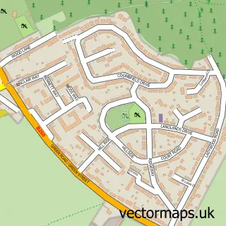
This Swanscombe street map is a detailed vector street map covering a 750m x 750m area. Select a larger area to create and download your own vector street map of Swanscombe.
The 750-metre map sample for Swanscombe covers 549 mapped buildings and approximately 19.1 km of road detail, of which 44 named roads are named. The immediate area includes 2 schools, 2 GP surgeries within 2 miles, 2 pubs and 2 MOT stations, with 15 within 2 miles. The wider area around Swanscombe features 2 tourism points of interest and 5 food and drink venues. To create a larger or custom map of Swanscombe, the map builder lets you define your own coverage area and download editable SVG, PDF and PNG files.
Create a larger editable map of Swanscombe
Choose any area you need and generate a high-quality vector map instantly. Perfect for print, planning, design, business and personal use.

This Swanscombe street map in Kent is available as downloadable SVG, PDF and PNG map files, or as a printed map for planning, business, display, education, local information and design work. You can also create a larger custom map area using the map selector.
What this Swanscombe map sample shows
Swanscombe lies within Swanscombe And Greenhithe Cp parish, part of Swanscombe ward in the Dartford District (B) local authority area. The postcode geography for this area includes the DA postcode area, the DA10 postcode district and the DA10 0 postcode sector. Residents fall under the Nhs Kent And Medway Integrated Care Board for NHS services.
Local features near Swanscombe
Within 2 milesAmenities and services in and around Swanscombe.
Administrative and postcode information for Swanscombe
The local authority covering Swanscombe is Dartford District (B), within the county of Kent. The settlement lies within Swanscombe ward and Swanscombe And Greenhithe Cp civil parish. The DA10 postcode district and DA10 0 postcode sector serve the immediate area. NHS provision in the area is delivered through Dartford And Gravesham Nhs Trust.
Nearby street map samples around Swanscombe

More street maps in Kent
750 metre map area coverage
Boundary, postcode and point of interest information for the 750m x 750m rectangle centred on this sample map.
Boundaries containing map centre
Constituency: Dartford Co Const
County: Kent County
District: Dartford District (B)
Icb: NHS Kent and Medway ICB
Parish: Swanscombe and Greenhithe CP
Police Force: kent
Postcode District: DA10
Postcode Sector: DA10 0
Ward: Swanscombe Ward
Nearby boundaries intersecting sample
Ward: Ebbsfleet Ward
Postcode coverage
POI category counts
Beauty Salon: 5
Public Health Clinic: 5
Elementary School: 4
Automotive Repair: 3
Church Cathedral: 3
Package Locker: 3
Building Supply Store: 2
Cafe: 2
Car Dealer: 2
Convenience Store: 2
Sample points of interest
- Firmgrip Accountancy Ltd.
- Swanscombe: St Peter & St Paul
- Angels Garage
- Autocentric
- Monarch Autos Repair Ltd
- Swanscombe Auto Centre
- Harry's Barbers
- The White Room Beauty
- Auream Aesthetics
- BabyJ Beauty
- Dreams Beauty Salon
- JL Nail Spa
Create a larger editable map of Swanscombe
This sample shows only a 750 metre area. To create a larger map of Swanscombe, use our map builder to choose your own coverage area, add titles and download editable SVG, PDF and PNG files.
Create a custom map of Swanscombe