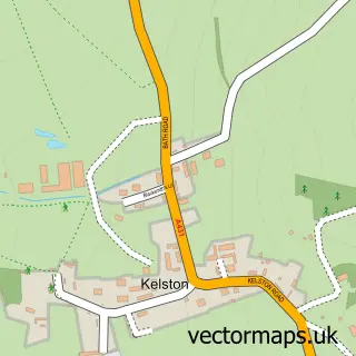
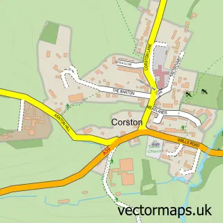
This Swineford street map is a detailed vector street map covering a 750m x 750m area. Select a larger area to create and download your own vector street map of Swineford.
The 750-metre map sample for Swineford covers 41 mapped buildings and approximately 4.2 km of road detail, of which 1 named road are named. The immediate area includes 2 pubs and 7 MOT stations within 2 miles. The wider area around Swineford features 1 tourism point of interest, 2 food and drink venues and 2 campsites within 2 miles. To create a larger or custom map of Swineford, the map builder lets you define your own coverage area and download editable SVG, PDF and PNG files.
Create a larger editable map of Swineford
Choose any area you need and generate a high-quality vector map instantly. Perfect for print, planning, design, business and personal use.

This Swineford street map in Gloucestershire is available as downloadable SVG, PDF and PNG map files, or as a printed map for planning, business, display, education, local information and design work. You can also create a larger custom map area using the map selector.
What this Swineford map sample shows
Swineford lies within Bitton Cp parish, part of Bitton & Oldland Common ward in the South Gloucestershire local authority area. The postcode geography for this area includes the BS postcode area, the BS30 postcode district and the BS30 6 postcode sector. Residents fall under the Nhs Bristol, North Somerset And South Gloucestershire Integrated Care Board for NHS services.
Local features near Swineford
Within 2 milesAmenities and services in and around Swineford.
Administrative and postcode information for Swineford
Swineford lies within Bitton Cp parish, part of Bitton & Oldland Common ward in the South Gloucestershire local authority area. The postcode geography for this area includes the BS postcode area, the BS30 postcode district and the BS30 6 postcode sector. Residents fall under the Nhs Bristol, North Somerset And South Gloucestershire Integrated Care Board for NHS services.
Nearby street map samples around Swineford

More street maps in Gloucestershire
750 metre map area coverage
Boundary, postcode and point of interest information for the 750m x 750m rectangle centred on this sample map.
Boundaries containing map centre
Constituency: North East Somerset and Hanham Co Const
District: South Gloucestershire
Icb: NHS Bristol North Somerset and South Gloucestershire ICB
Parish: Bitton CP
Police Force: avon and somerset
Postcode District: BS30
Postcode Sector: BS30 6
Ward: Bitton & Oldland Common Ward
Nearby boundaries intersecting sample
Constituency: Bath Co Const
District: Bath and North East Somerset
Icb: NHS Bath and North East Somerset Swindon and Wiltshire ICB
Parish: North Stoke CP, Saltford CP
Postcode District: BA1, BS31
Postcode Sector: BA1 9, BS31 3
Ward: Newbridge Ward, Saltford Ward
Postcode coverage
POI category counts
Preschool: 2
Pub: 2
Attractions And Activities: 1
Business Management Services: 1
Education: 1
Engineering Services: 1
Property Management: 1
Water Supplier: 1
Sample points of interest
- Swineford
- Plant Care
- Bitton Pre School
- Coppermill Engineering
- Leaping Lambs Nursery Ltd.
- Swineford Nursery and Preschool
- PSG Building Services
- Swan Inn Swineford
- The Swan Inn
- Swineford Lock
Create a larger editable map of Swineford
This sample shows only a 750 metre area. To create a larger map of Swineford, use our map builder to choose your own coverage area, add titles and download editable SVG, PDF and PNG files.
Create a custom map of Swineford