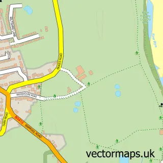
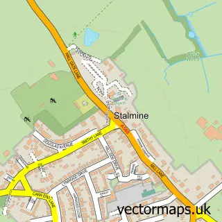
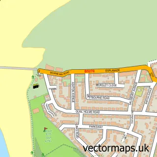
This Thornton street map is a detailed vector street map covering a 750m x 750m area. Select a larger area to create and download your own vector street map of Thornton.
The 750-metre map sample for Thornton covers 598 mapped buildings and approximately 19.6 km of road detail, of which 55 named roads are named. The immediate area includes 1 school, 2 GP surgeries, with 6 within 2 miles, 3 pubs and 13 MOT stations within 2 miles. The wider area around Thornton features 2 tourism points of interest and 6 food and drink venues. To create a larger or custom map of Thornton, the map builder lets you define your own coverage area and download editable SVG, PDF and PNG files.
Create a larger editable map of Thornton
Choose any area you need and generate a high-quality vector map instantly. Perfect for print, planning, design, business and personal use.

This Thornton street map in Lancashire is available as downloadable SVG, PDF and PNG map files, or as a printed map for planning, business, display, education, local information and design work. You can also create a larger custom map area using the map selector.
What this Thornton map sample shows
Thornton lies within Lancashire County parish, part of Stanah ward in the Wyre District (B) local authority area. The postcode geography for this area includes the FY postcode area, the FY5 postcode district and the FY5 5 postcode sector. Residents fall under the Nhs Lancashire And South Cumbria Integrated Care Board for NHS services.
Local features near Thornton
Within 2 milesAmenities and services in and around Thornton.
Administrative and postcode information for Thornton
The local authority covering Thornton is Wyre District (B), within the county of Lancashire. The settlement lies within Stanah ward and Lancashire County civil parish. The FY5 postcode district and FY5 5 postcode sector serve the immediate area. NHS provision in the area is delivered through Blackpool Teaching Hospitals Nhs Foundation Trust.
Nearby street map samples around Thornton

More street maps in Lancashire
750 metre map area coverage
Boundary, postcode and point of interest information for the 750m x 750m rectangle centred on this sample map.
Boundaries containing map centre
Constituency: Blackpool North and Fleetwood Boro Const
County: Lancashire County
District: Wyre District (B)
Icb: NHS Lancashire and South Cumbria ICB
Police Force: lancashire
Postcode District: FY5
Postcode Sector: FY5 4
Ward: Bourne Ward
Nearby boundaries intersecting sample
Postcode Sector: FY5 2, FY5 3
Ward: Marsh Mill Ward
Postcode coverage
POI category counts
Beauty Salon: 9
Convenience Store: 4
Gas Station: 4
Beauty Product Supplier: 3
Contractor: 3
Food Delivery Service: 3
Plumbing: 3
Pub: 3
Sports Club And League: 3
Beauty And Spa: 2
Sample points of interest
- Brown & Co
- Greenbox Media
- Paul Nicholas School of Acting
- Windmill Craft Centre
- Barber Shop
- Crossleys Bathrooms
- CMK Wellness & Beauty
- SHS Visionary Hair & Beauty
- E F X Hair
- Sunshine For The Soul
- Sunshine for The Soul - Organic Beauty & Holistic Therapies
- Anais Aesthetics
Create a larger editable map of Thornton
This sample shows only a 750 metre area. To create a larger map of Thornton, use our map builder to choose your own coverage area, add titles and download editable SVG, PDF and PNG files.
Create a custom map of Thornton