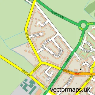
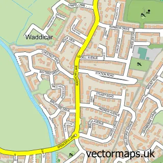
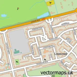
This Bootle street map is a detailed vector street map covering a 750m x 750m area. Select a larger area to create and download your own vector street map of Bootle.
The 750-metre map sample for Bootle covers 279 mapped buildings and approximately 21.0 km of road detail, of which 46 named roads are named. The immediate area includes 1 railway station, 2 GP surgeries, with 21 within 2 miles, 9 pubs and 3 MOT stations, with 48 within 2 miles. The wider area around Bootle features 1 tourism point of interest and 25 food and drink venues. To create a larger or custom map of Bootle, the map builder lets you define your own coverage area and download editable SVG, PDF and PNG files.
Create a larger editable map of Bootle
Choose any area you need and generate a high-quality vector map instantly. Perfect for print, planning, design, business and personal use.

This Bootle street map in Merseyside is available as downloadable SVG, PDF and PNG map files, or as a printed map for planning, business, display, education, local information and design work. You can also create a larger custom map area using the map selector.
What this Bootle map sample shows
Bootle lies within Sefton District (B) parish, part of Linacre ward in the Sefton District (B) local authority area. The postcode geography for this area includes the L postcode area, the L20 postcode district and the L20 4 postcode sector. Residents fall under the Nhs Cheshire And Merseyside Integrated Care Board for NHS services.
Local features near Bootle
Within 2 milesAmenities and services in and around Bootle.
Administrative and postcode information for Bootle
Bootle lies within Sefton District (B) parish, part of Linacre ward in the Sefton District (B) local authority area. The postcode geography for this area includes the L postcode area, the L20 postcode district and the L20 4 postcode sector. Residents fall under the Nhs Cheshire And Merseyside Integrated Care Board for NHS services.
Nearby street map samples around Bootle

More street maps in Merseyside
750 metre map area coverage
Boundary, postcode and point of interest information for the 750m x 750m rectangle centred on this sample map.
Boundaries containing map centre
Constituency: Bootle Boro Const
District: Sefton District (B)
Icb: NHS Lancashire and South Cumbria ICB
Police Force: merseyside
Postcode District: L20
Postcode Sector: L20 4
Ward: Linacre Ward
Nearby boundaries intersecting sample
Postcode Sector: L20 3, L20 5, L20 7, L20 8
Ward: Derby Ward
Postcode coverage
POI category counts
Automotive Repair: 15
Mobile Phone Store: 10
Charity Organization: 9
Discount Store: 9
Pub: 9
Bakery: 7
Banks: 7
Clothing Store: 7
Retail: 7
Coffee Shop: 6
Sample points of interest
- Antrec Bootle
- Asset Training & Consultancy Limited
- RAIBS
- Lynn’s Bazaar
- Titheringtons
- Bootle pets & Aquatics
- ATM (Post Office)
- Cash machine The Esplanade
- GAP Plant & Tool Hire
- Bootle Upholstery
- Strand Road Garage
- Berry Street Garage
Create a larger editable map of Bootle
This sample shows only a 750 metre area. To create a larger map of Bootle, use our map builder to choose your own coverage area, add titles and download editable SVG, PDF and PNG files.
Create a custom map of Bootle