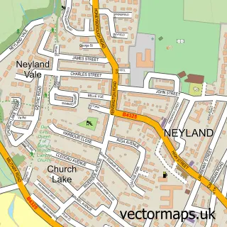
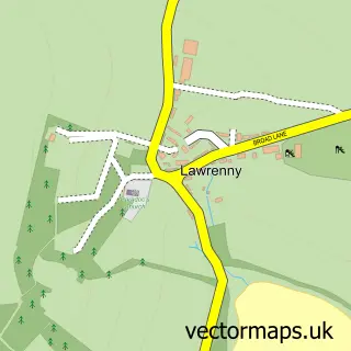
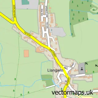
This Burton street map is a detailed vector street map covering a 750m x 750m area. Select a larger area to create and download your own vector street map of Burton.
The 750-metre map sample for Burton covers 122 mapped buildings and approximately 5.5 km of road detail, of which 7 named roads are named. The immediate area includes 5 MOT stations within 2 miles. To create a larger or custom map of Burton, the map builder lets you define your own coverage area and download editable SVG, PDF and PNG files.
Create a larger editable map of Burton
Choose any area you need and generate a high-quality vector map instantly. Perfect for print, planning, design, business and personal use.

This Burton street map in Dyfed is available as downloadable SVG, PDF and PNG map files, or as a printed map for planning, business, display, education, local information and design work. You can also create a larger custom map area using the map selector.
What this Burton map sample shows
Burton lies within Burton Community parish, part of Burton ward in the Sir Benfro - Pembrokeshire local authority area. The postcode geography for this area includes the SA postcode area, the SA73 postcode district and the SA73 1 postcode sector. Residents fall under the Hywel Dda University Health Board for NHS services.
Local features near Burton
Within 2 milesAmenities and services in and around Burton.
Administrative and postcode information for Burton
The local authority covering Burton is Sir Benfro - Pembrokeshire, within the county of Dyfed. The settlement lies within Burton ward and Burton Community civil parish. The SA73 postcode district and SA73 1 postcode sector serve the immediate area. NHS provision in the area is delivered through Hywel Dda University Health Board.
Nearby street map samples around Burton

More street maps in Dyfed
750 metre map area coverage
Boundary, postcode and point of interest information for the 750m x 750m rectangle centred on this sample map.
Boundaries containing map centre
Constituency: Mid and South Pembrokeshire Co Const
District: Sir Benfro - Pembrokeshire
Icb: Hywel Dda
Parish: Burton Community
Police Force: dyfed-powys
Postcode District: SA73
Postcode Sector: SA73 1
Nearby boundaries intersecting sample
No additional intersecting boundaries found.
Postcode coverage
POI category counts
Church Cathedral: 1
Convenience Store: 1
Health And Medical: 1
Mortgage Broker: 1
Professional Services: 1
Sample points of interest
- St Mary’s Church Burton
- Nisa Local Haven Bridge Rd Neyland
- Swansea University Osteopathic Clinic
- Tanya Absalom Mortgages
- Rudders Boatyard
Create a larger editable map of Burton
This sample shows only a 750 metre area. To create a larger map of Burton, use our map builder to choose your own coverage area, add titles and download editable SVG, PDF and PNG files.
Create a custom map of Burton