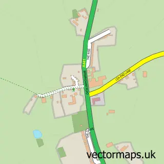
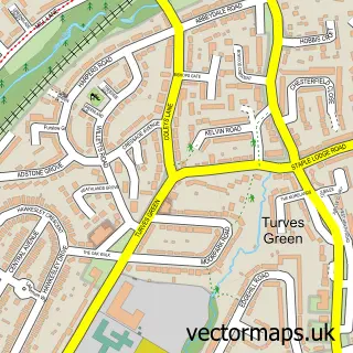
This Cofton Hackett street map is a detailed vector street map covering a 750m x 750m area. Select a larger area to create and download your own vector street map of Cofton Hackett.
The 750-metre map sample for Cofton Hackett covers 175 mapped buildings and approximately 16.5 km of road detail, of which 12 named roads are named. The immediate area includes 6 GP surgeries within 2 miles and 8 MOT stations within 2 miles. To create a larger or custom map of Cofton Hackett, the map builder lets you define your own coverage area and download editable SVG, PDF and PNG files.
Create a larger editable map of Cofton Hackett
Choose any area you need and generate a high-quality vector map instantly. Perfect for print, planning, design, business and personal use.

This Cofton Hackett street map in Worcestershire is available as downloadable SVG, PDF and PNG map files, or as a printed map for planning, business, display, education, local information and design work. You can also create a larger custom map area using the map selector.
What this Cofton Hackett map sample shows
Cofton Hackett lies within Cofton Hackett Cp parish, part of Cofton ward in the Bromsgrove District local authority area. The postcode geography for this area includes the B postcode area, the B45 postcode district and the B45 8 postcode sector. Residents fall under the Nhs Herefordshire And Worcestershire Integrated Care Board for NHS services.
Local features near Cofton Hackett
Within 2 milesAmenities and services in and around Cofton Hackett.
Administrative and postcode information for Cofton Hackett
Cofton Hackett lies within Cofton Hackett Cp parish, part of Cofton ward in the Bromsgrove District local authority area. The postcode geography for this area includes the B postcode area, the B45 postcode district and the B45 8 postcode sector. Residents fall under the Nhs Herefordshire And Worcestershire Integrated Care Board for NHS services.
Nearby street map samples around Cofton Hackett

More street maps in Worcestershire
750 metre map area coverage
Boundary, postcode and point of interest information for the 750m x 750m rectangle centred on this sample map.
Boundaries containing map centre
Constituency: Bromsgrove Co Const
County: Worcestershire County
District: Bromsgrove District
Icb: NHS Herefordshire and Worcestershire ICB
Parish: Cofton Hackett CP
Police Force: west mercia
Postcode District: B45
Postcode Sector: B45 8
Ward: Cofton Ward
Nearby boundaries intersecting sample
No additional intersecting boundaries found.
Postcode coverage
POI category counts
Machine And Tool Rentals: 2
Airport Shuttles: 1
Alternative Medicine: 1
Building Supply Store: 1
Computer Coaching: 1
Doctor: 1
Dog Trainer: 1
Home Decor: 1
It Service And Computer Repair: 1
Lake: 1
Sample points of interest
- Top Chauffeur | Airport Transfers & Executive Car Hire
- New Horizons Hypno Coaching
- Classic Carpentry
- Design Training
- The Arrowbank Chiropractic Clinic
- Puppy Paws Training
- Seeing The Big Picture
- Obd Experts
- Cofton Lake
- Plant Hire Now Ltd. - Mini Digger Hire Birmingham
- Planthirenow.co.uk
- Ei Mei Kan
Create a larger editable map of Cofton Hackett
This sample shows only a 750 metre area. To create a larger map of Cofton Hackett, use our map builder to choose your own coverage area, add titles and download editable SVG, PDF and PNG files.
Create a custom map of Cofton Hackett