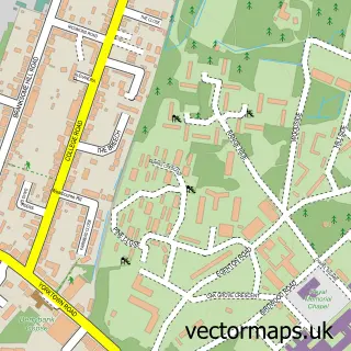
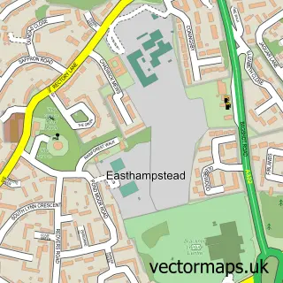
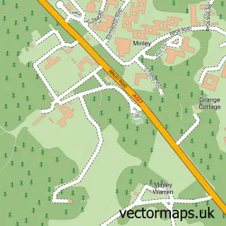
This Crowthorne street map is a detailed vector street map covering a 750m x 750m area. Select a larger area to create and download your own vector street map of Crowthorne.
The 750-metre map sample for Crowthorne covers 567 mapped buildings and approximately 18.8 km of road detail, of which 36 named roads are named. The immediate area includes 1 school, 1 GP surgery within 2 miles, 4 pubs and 1 MOT station, with 5 within 2 miles. The wider area around Crowthorne features 10 food and drink venues. To create a larger or custom map of Crowthorne, the map builder lets you define your own coverage area and download editable SVG, PDF and PNG files.
Create a larger editable map of Crowthorne
Choose any area you need and generate a high-quality vector map instantly. Perfect for print, planning, design, business and personal use.

This Crowthorne street map in Berkshire is available as downloadable SVG, PDF and PNG map files, or as a printed map for planning, business, display, education, local information and design work. You can also create a larger custom map area using the map selector.
What this Crowthorne map sample shows
Crowthorne lies within Crowthorne Cp parish, part of Crowthorne ward in the Bracknell Forest (B) local authority area. The postcode geography for this area includes the RG postcode area, the RG45 postcode district and the RG45 7 postcode sector. Residents fall under the Nhs Frimley Integrated Care Board for NHS services.
Local features near Crowthorne
Within 2 milesAmenities and services in and around Crowthorne.
Administrative and postcode information for Crowthorne
The local authority covering Crowthorne is Bracknell Forest (B), within the county of Berkshire. The settlement lies within Crowthorne ward and Crowthorne Cp civil parish. The RG45 postcode district and RG45 7 postcode sector serve the immediate area. NHS provision in the area is delivered through Frimley Health Nhs Foundation Trust.
Nearby street map samples around Crowthorne

More street maps in Berkshire
750 metre map area coverage
Boundary, postcode and point of interest information for the 750m x 750m rectangle centred on this sample map.
Boundaries containing map centre
Constituency: Bracknell Boro Const
District: Bracknell Forest (B)
Icb: NHS Frimley ICB
Parish: Crowthorne CP
Police Force: thames valley
Postcode District: RG45
Postcode Sector: RG45 6
Ward: Crowthorne Ward
Nearby boundaries intersecting sample
Constituency: Wokingham Co Const
District: Wokingham (B)
Icb: NHS Thames Valley ICB
Parish: Wokingham Without CP
Postcode Sector: RG45 7
Ward: Wokingham Without Ward
Postcode coverage
POI category counts
Beauty Salon: 6
Financial Service: 5
It Service And Computer Repair: 5
Accountant: 4
Advertising Agency: 4
Contractor: 4
Dentist: 4
Hair Salon: 4
Naturopathic Holistic: 4
Professional Services: 4
Sample points of interest
- AAS Accountants
- Elsburys
- Go Accounting Ltd
- Rice Associates
- One Acupuncture Clinic
- E S P
- Sportsguide
- Taskforce Group
- Viney Communications
- Best Balance Bodywork
- Carolyn Potter At Crowthorne Hypnotherapy
- The Parish Church of St John the Baptist
Create a larger editable map of Crowthorne
This sample shows only a 750 metre area. To create a larger map of Crowthorne, use our map builder to choose your own coverage area, add titles and download editable SVG, PDF and PNG files.
Create a custom map of Crowthorne