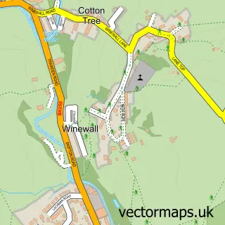
This Foulridge street map is a detailed vector street map covering a 750m x 750m area. Select a larger area to create and download your own vector street map of Foulridge.
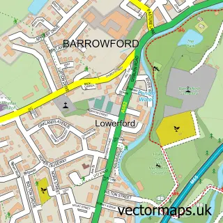
The 750-metre map sample for Foulridge covers 275 mapped buildings and approximately 13.1 km of road detail, of which 30 named roads are named. The immediate area includes 1 GP surgery within 2 miles, 3 pubs and 1 MOT station, with 12 within 2 miles. The wider area around Foulridge features 1 tourism point of interest and 6 food and drink venues. To create a larger or custom map of Foulridge, the map builder lets you define your own coverage area and download editable SVG, PDF and PNG files.
Create a larger editable map of Foulridge
Choose any area you need and generate a high-quality vector map instantly. Perfect for print, planning, design, business and personal use.

This Foulridge street map in Lancashire is available as downloadable SVG, PDF and PNG map files, or as a printed map for planning, business, display, education, local information and design work. You can also create a larger custom map area using the map selector.
What this Foulridge map sample shows
Foulridge lies within Foulridge Cp parish, part of Foulridge ward in the Pendle District (B) local authority area. The postcode geography for this area includes the BB postcode area, the BB8 postcode district and the BB8 7 postcode sector. Residents fall under the Nhs Lancashire And South Cumbria Integrated Care Board for NHS services.
Local features near Foulridge
Within 2 milesAmenities and services in and around Foulridge.
Administrative and postcode information for Foulridge
Foulridge lies within Foulridge Cp parish, part of Foulridge ward in the Pendle District (B) local authority area. The postcode geography for this area includes the BB postcode area, the BB8 postcode district and the BB8 7 postcode sector. Residents fall under the Nhs Lancashire And South Cumbria Integrated Care Board for NHS services.
Nearby street map samples around Foulridge

More street maps in Lancashire
750 metre map area coverage
Boundary, postcode and point of interest information for the 750m x 750m rectangle centred on this sample map.
Boundaries containing map centre
Constituency: Pendle and Clitheroe Co Const
County: Lancashire County
District: Pendle District (B)
Icb: NHS Lancashire and South Cumbria ICB
Parish: Foulridge CP
Police Force: lancashire
Postcode District: BB8
Postcode Sector: BB8 7
Ward: Boulsworth & Foulridge Ward
Nearby boundaries intersecting sample
No additional intersecting boundaries found.
Postcode coverage
POI category counts
Beauty Salon: 3
Pub: 3
Cafe: 2
Electrician: 2
Sports Club And League: 2
Anglican Church: 1
Appliance Repair Service: 1
Architect: 1
Bridal Shop: 1
Building Contractor: 1
Sample points of interest
- St Michael and All Angels, Foulridge
- Ian Morris Appliances
- Classic Architecture
- Colour Hut By Chantelle
- Darpo Hair Spa
- Wharfcottage hairport
- Storey Crafts
- Kawa Construction Ltd.
- L F Electrical
- Inghams Butchers
- Caf+® Cargo
- Cafe Cargo
Create a larger editable map of Foulridge
This sample shows only a 750 metre area. To create a larger map of Foulridge, use our map builder to choose your own coverage area, add titles and download editable SVG, PDF and PNG files.
Create a custom map of Foulridge