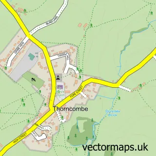
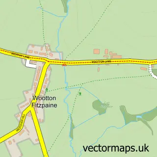
This Hawkchurch street map is a detailed vector street map covering a 750m x 750m area. Select a larger area to create and download your own vector street map of Hawkchurch.
The 750-metre map sample for Hawkchurch covers 134 mapped buildings and approximately 8.4 km of road detail, of which 5 named roads are named. The immediate area includes 1 pub. The wider area around Hawkchurch features 2 food and drink venues and 1 hotel. To create a larger or custom map of Hawkchurch, the map builder lets you define your own coverage area and download editable SVG, PDF and PNG files.
Create a larger editable map of Hawkchurch
Choose any area you need and generate a high-quality vector map instantly. Perfect for print, planning, design, business and personal use.

This Hawkchurch street map in Devon is available as downloadable SVG, PDF and PNG map files, or as a printed map for planning, business, display, education, local information and design work. You can also create a larger custom map area using the map selector.
What this Hawkchurch map sample shows
Hawkchurch lies within Hawkchurch Cp parish, part of Yarty ward in the East Devon District local authority area. The postcode geography for this area includes the EX postcode area, the EX13 postcode district and the EX13 5 postcode sector. Residents fall under the Nhs Devon Integrated Care Board for NHS services.
Local features near Hawkchurch
Within 2 milesAmenities and services in and around Hawkchurch.
Administrative and postcode information for Hawkchurch
The local authority covering Hawkchurch is East Devon District, within the county of Devon. The settlement lies within Yarty ward and Hawkchurch Cp civil parish. The EX13 postcode district and EX13 5 postcode sector serve the immediate area. NHS provision in the area is delivered through Royal Devon University Healthcare Nhs Foundation Trust.
Nearby street map samples around Hawkchurch

More street maps in Devon
750 metre map area coverage
Boundary, postcode and point of interest information for the 750m x 750m rectangle centred on this sample map.
Boundaries containing map centre
Constituency: Honiton and Sidmouth Co Const
County: Devon County
District: East Devon District
Icb: NHS Devon ICB
Parish: Hawkchurch CP
Police Force: devon and cornwall
Postcode District: EX13
Postcode Sector: EX13 5
Ward: Yarty Ward
Nearby boundaries intersecting sample
No additional intersecting boundaries found.
Postcode coverage
POI category counts
Anglican Church: 1
Automotive Repair: 1
Banks: 1
Building Contractor: 1
Church Cathedral: 1
Elementary School: 1
Holiday Rental Home: 1
Hotel: 1
Life Coach: 1
Printing Services: 1
Sample points of interest
- Hawkchurch: St John the Baptist
- Autoworx Engineering
- NatWest
- Martin Nutkins Window Cleaning
- St John The Baptist Church
- Hawkchurch Church of England Primary School
- Angels farm
- The Vineyards B&B
- Tommy Bastin Coaching
- Hawkchurch Village
- The Old Inn
- The Old Inn, Hawkchurch
Create a larger editable map of Hawkchurch
This sample shows only a 750 metre area. To create a larger map of Hawkchurch, use our map builder to choose your own coverage area, add titles and download editable SVG, PDF and PNG files.
Create a custom map of Hawkchurch