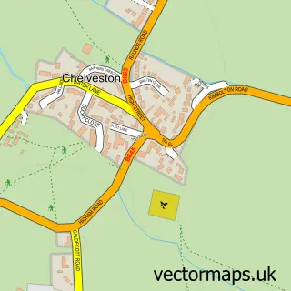
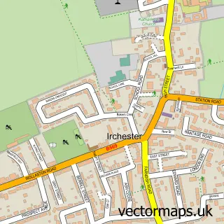
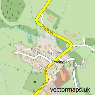
This Higham Ferrers street map is a detailed vector street map covering a 750m x 750m area. Select a larger area to create and download your own vector street map of Higham Ferrers.
The 750-metre map sample for Higham Ferrers covers 420 mapped buildings and approximately 30.1 km of road detail, of which 39 named roads are named. The immediate area includes 2 primary schools and 1 secondary school, 1 GP surgery, with 5 within 2 miles, 4 pubs and 1 MOT station, with 16 within 2 miles. The wider area around Higham Ferrers features 5 tourism points of interest, 10 food and drink venues and 1 hotel. To create a larger or custom map of Higham Ferrers, the map builder lets you define your own coverage area and download editable SVG, PDF and PNG files.
Create a larger editable map of Higham Ferrers
Choose any area you need and generate a high-quality vector map instantly. Perfect for print, planning, design, business and personal use.

This Higham Ferrers street map in Northamptonshire is available as downloadable SVG, PDF and PNG map files, or as a printed map for planning, business, display, education, local information and design work. You can also create a larger custom map area using the map selector.
What this Higham Ferrers map sample shows
Higham Ferrers lies within Higham Ferrers Cp parish, part of Higham Ferrers Lancaster ward in the North Northamptonshire local authority area. The postcode geography for this area includes the NN postcode area, the NN10 postcode district and the NN10 8 postcode sector. Residents fall under the Nhs Northamptonshire Integrated Care Board for NHS services.
Local features near Higham Ferrers
Within 2 milesAmenities and services in and around Higham Ferrers.
Administrative and postcode information for Higham Ferrers
Higham Ferrers lies within Higham Ferrers Cp parish, part of Higham Ferrers Lancaster ward in the North Northamptonshire local authority area. The postcode geography for this area includes the NN postcode area, the NN10 postcode district and the NN10 8 postcode sector. Residents fall under the Nhs Northamptonshire Integrated Care Board for NHS services.
Nearby street map samples around Higham Ferrers

More street maps in Northamptonshire
750 metre map area coverage
Boundary, postcode and point of interest information for the 750m x 750m rectangle centred on this sample map.
Boundaries containing map centre
Constituency: Wellingborough and Rushden Co Const
District: North Northamptonshire
Icb: NHS Northamptonshire ICB
Parish: Higham Ferrers CP
Police Force: northamptonshire
Postcode District: NN10
Postcode Sector: NN10 8
Ward: Higham Ferrers Ward
Nearby boundaries intersecting sample
No additional intersecting boundaries found.
Postcode coverage
POI category counts
Hair Salon: 5
Automotive Repair: 4
Coffee Shop: 4
Pub: 4
Retail: 4
Sports Club And League: 4
Bakery: 3
Building Supply Store: 3
Dentist: 3
Park: 3
Sample points of interest
- DMO Accountants Higham Ferrers
- Willsons Chartered Accountants
- Healing Well
- Sidey Design Architecture
- Sidey Design Associates
- Millers Yarns and Crafts
- Trylon
- Golden Pavilion
- The Cooperative Food (BF) Higham Ferrers, Higham Ferrers
- Saffron Road Recreation Ground
- R S Repairs
- Ace Auto Electrical
Create a larger editable map of Higham Ferrers
This sample shows only a 750 metre area. To create a larger map of Higham Ferrers, use our map builder to choose your own coverage area, add titles and download editable SVG, PDF and PNG files.
Create a custom map of Higham Ferrers