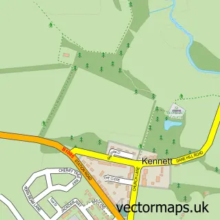
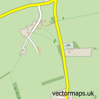
This Kentford street map is a detailed vector street map covering a 750m x 750m area. Select a larger area to create and download your own vector street map of Kentford.
The 750-metre map sample for Kentford covers 124 mapped buildings and approximately 11.4 km of road detail, of which 8 named roads are named. The immediate area includes 1 pub and 1 MOT station, with 2 within 2 miles. The wider area around Kentford features 1 food and drink venue. To create a larger or custom map of Kentford, the map builder lets you define your own coverage area and download editable SVG, PDF and PNG files.
Create a larger editable map of Kentford
Choose any area you need and generate a high-quality vector map instantly. Perfect for print, planning, design, business and personal use.

This Kentford street map in Suffolk is available as downloadable SVG, PDF and PNG map files, or as a printed map for planning, business, display, education, local information and design work. You can also create a larger custom map area using the map selector.
What this Kentford map sample shows
Kentford lies within Kentford Cp parish, part of Kentford & Moulton ward in the West Suffolk District local authority area. The postcode geography for this area includes the CB postcode area, the CB8 postcode district and the CB8 7 postcode sector. Residents fall under the Nhs Suffolk And North East Essex Integrated Care Board for NHS services.
Local features near Kentford
Within 2 milesAmenities and services in and around Kentford.
Administrative and postcode information for Kentford
The local authority covering Kentford is West Suffolk District, within the county of Suffolk. The settlement lies within Kentford & Moulton ward and Kentford Cp civil parish. The CB8 postcode district and CB8 7 postcode sector serve the immediate area. NHS provision in the area is delivered through West Suffolk Nhs Foundation Trust.
Nearby street map samples around Kentford


More street maps in Suffolk
750 metre map area coverage
Boundary, postcode and point of interest information for the 750m x 750m rectangle centred on this sample map.
Boundaries containing map centre
Constituency: West Suffolk Co Const
County: Suffolk County
District: West Suffolk District
Icb: NHS Essex ICB
Parish: Kentford CP
Police Force: suffolk
Postcode District: CB8
Postcode Sector: CB8 7
Ward: Kentford & Moulton Ward
Nearby boundaries intersecting sample
Postcode Sector: CB8 8
Postcode coverage
POI category counts
Agricultural Seed Store: 1
Alternative Medicine: 1
Arts And Entertainment: 1
Automotive Repair: 1
Building Supply Store: 1
Car Dealer: 1
Nursery And Gardening: 1
Pet Groomer: 1
Physical Therapy: 1
Pub: 1
Sample points of interest
- Johnson's Seeds
- The Healthy Mind and Body Co
- Kentford
- B15 Bike and Car MOT Centre
- Knappett Roofing
- Kentford Car Sales
- Mr Fothergills Seeds Ltd
- The Trimming Room
- The Sports Injury Clinic
- The Kentford
- Johnson's Seeds
- Driving Miss Daisy Newmarket
Create a larger editable map of Kentford
This sample shows only a 750 metre area. To create a larger map of Kentford, use our map builder to choose your own coverage area, add titles and download editable SVG, PDF and PNG files.
Create a custom map of Kentford