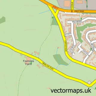
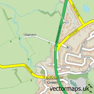
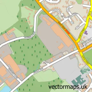
This Kidsgrove street map is a detailed vector street map covering a 750m x 750m area. Select a larger area to create and download your own vector street map of Kidsgrove.
The 750-metre map sample for Kidsgrove covers 429 mapped buildings and approximately 18.5 km of road detail, of which 43 named roads are named. The immediate area includes 2 schools, 2 GP surgeries, with 5 within 2 miles, 4 pubs and 10 MOT stations within 2 miles. The wider area around Kidsgrove features 1 tourism point of interest, 10 food and drink venues and 1 hotel. To create a larger or custom map of Kidsgrove, the map builder lets you define your own coverage area and download editable SVG, PDF and PNG files.
Create a larger editable map of Kidsgrove
Choose any area you need and generate a high-quality vector map instantly. Perfect for print, planning, design, business and personal use.

This Kidsgrove street map in Staffordshire is available as downloadable SVG, PDF and PNG map files, or as a printed map for planning, business, display, education, local information and design work. You can also create a larger custom map area using the map selector.
What this Kidsgrove map sample shows
Kidsgrove lies within Kidsgrove Cp parish, part of Kidsgrove & Ravenscliffe ward in the Newcastle-Under-Lyme District (B) local authority area. The postcode geography for this area includes the ST postcode area, the ST7 postcode district and the ST7 1 postcode sector. Residents fall under the Nhs Staffordshire And Stoke-On-Trent Integrated Care Board for NHS services.
Local features near Kidsgrove
Within 2 milesAmenities and services in and around Kidsgrove.
Administrative and postcode information for Kidsgrove
The local authority covering Kidsgrove is Newcastle-Under-Lyme District (B), within the county of Staffordshire. The settlement lies within Kidsgrove & Ravenscliffe ward and Kidsgrove Cp civil parish. The ST7 postcode district and ST7 1 postcode sector serve the immediate area. NHS provision in the area is delivered through University Hospitals Of North Midlands Nhs Trust.
Nearby street map samples around Kidsgrove

More street maps in Staffordshire
750 metre map area coverage
Boundary, postcode and point of interest information for the 750m x 750m rectangle centred on this sample map.
Boundaries containing map centre
Constituency: Stoke-on-Trent North Boro Const
County: Staffordshire County
District: Newcastle-under-Lyme District (B)
Icb: NHS Staffordshire and Stoke-on-Trent ICB
Parish: Kidsgrove CP
Police Force: staffordshire
Postcode District: ST7
Postcode Sector: ST7 4
Ward: Kidsgrove & Ravenscliffe Ward
Nearby boundaries intersecting sample
Postcode Sector: ST7 1
Postcode coverage
POI category counts
Beauty Salon: 11
Beauty And Spa: 9
Hair Salon: 9
Fast Food Restaurant: 7
Tanning Salon: 5
Bakery: 4
Bar: 4
Barber: 4
Pub: 4
Automotive Repair: 3
Sample points of interest
- The Fitness Collab
- British Red Cross
- Army Jobs
- The Oriental Pearl
- Payzone
- Bargain Tyres
- General Traffic
- Sgp Performance, Car Restoration
- Hamilton's Bake Shop
- Kidsgrove Oatcakes
- The Bakery
- Wrights Pies Kidsgrove
Create a larger editable map of Kidsgrove
This sample shows only a 750 metre area. To create a larger map of Kidsgrove, use our map builder to choose your own coverage area, add titles and download editable SVG, PDF and PNG files.
Create a custom map of Kidsgrove