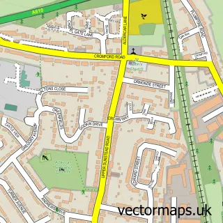
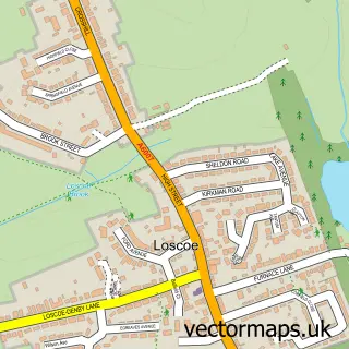
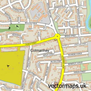
This Langley Mill street map is a detailed vector street map covering a 750m x 750m area. Select a larger area to create and download your own vector street map of Langley Mill.
The 750-metre map sample for Langley Mill covers 449 mapped buildings and approximately 24.0 km of road detail, of which 38 named roads are named. The immediate area includes 1 school, 1 railway station, 5 GP surgeries within 2 miles and 1 pub among other local services. The wider area around Langley Mill features 1 food and drink venue and 1 hotel. To create a larger or custom map of Langley Mill, the map builder lets you define your own coverage area and download editable SVG, PDF and PNG files.
Create a larger editable map of Langley Mill
Choose any area you need and generate a high-quality vector map instantly. Perfect for print, planning, design, business and personal use.

This Langley Mill street map in Derbyshire is available as downloadable SVG, PDF and PNG map files, or as a printed map for planning, business, display, education, local information and design work. You can also create a larger custom map area using the map selector.
What this Langley Mill map sample shows
Langley Mill lies within Aldercar And Langley Mill Cp parish, part of Langley Mill And Aldercar ward in the Amber Valley District (B) local authority area. The postcode geography for this area includes the NG postcode area, the NG16 postcode district and the NG16 4 postcode sector. Residents fall under the Nhs Derby And Derbyshire Integrated Care Board for NHS services.
Local features near Langley Mill
Within 2 milesAmenities and services in and around Langley Mill.
Administrative and postcode information for Langley Mill
The local authority covering Langley Mill is Amber Valley District (B), within the county of Derbyshire. The settlement lies within Langley Mill And Aldercar ward and Aldercar And Langley Mill Cp civil parish. The NG16 postcode district and NG16 4 postcode sector serve the immediate area. NHS provision in the area is delivered through University Hospitals Of Derby And Burton Nhs Foundation Trust.
Nearby street map samples around Langley Mill

More street maps in Derbyshire
750 metre map area coverage
Boundary, postcode and point of interest information for the 750m x 750m rectangle centred on this sample map.
Boundaries containing map centre
Constituency: Amber Valley Co Const
County: Derbyshire County
District: Amber Valley District (B)
Icb: NHS Derby and Derbyshire ICB
Parish: Aldercar and Langley Mill CP
Police Force: derbyshire
Postcode District: NG16
Postcode Sector: NG16 4
Ward: Codnor, Langley Mill & Aldercar Ward
Nearby boundaries intersecting sample
Parish: Heanor and Loscoe CP
Postcode District: DE75
Postcode Sector: DE75 7
Ward: Heanor East Ward, Heanor West & Loscoe Ward
Postcode coverage
POI category counts
Beauty Salon: 7
Building Supply Store: 7
Automotive Repair: 5
Hair Salon: 5
Event Planning: 4
Party And Event Planning: 4
Automotive Services And Repair: 3
Contractor: 3
Advertising Agency: 2
Arts And Entertainment: 2
Sample points of interest
- Burnsides
- Page Whelan Design & Print
- St Andrews Church Langley Mill
- Poly-Props Ltd
- Stag.com
- Stag.com
- Central England Co-Op - Langley Mill, Langley Mill
- Topgear Tuning Nottingham & Derby
- The Motor Shop
- AB Tuning
- Ab Tuning Limited
- Kirk's Garage
Create a larger editable map of Langley Mill
This sample shows only a 750 metre area. To create a larger map of Langley Mill, use our map builder to choose your own coverage area, add titles and download editable SVG, PDF and PNG files.
Create a custom map of Langley Mill